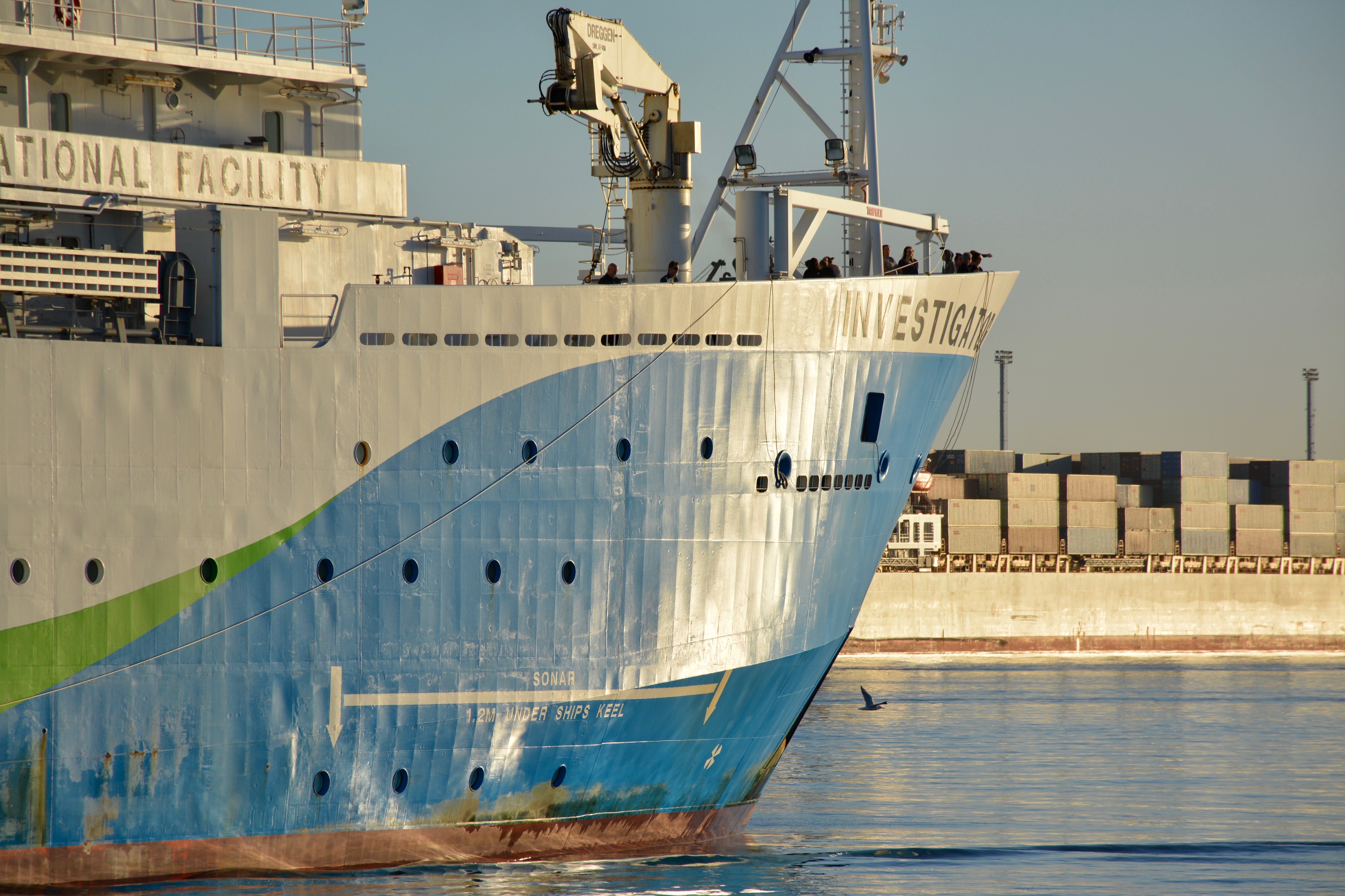
Australia's world-class marine research capability
The ocean plays an influential role in the everyday lives, economy, health and well-being of all Australians and we are rightly proud to be the custodians of the third largest marine estate in the world.
Understanding and ultimately managing the diverse ecosystems and industries of this vast area is challenging and requires navigational, sampling and data collection capabilities fit to meet the diverse needs of users.
Funded by the Australian Government, owned and operated by CSIRO on behalf of the nation under the oversight of an independent Steering Committee, the Marine National Facility (MNF) provides a blue-water research capability to the Australian research community and their international collaborators. The MNF is made up of: the ocean class research vessel Investigator; a suite of scientific equipment and instrumentation; a collection of marine data collected since the MNF’s creation; and the expertise required to manage an ocean-going research platform and support vessel users.
The research delivered from MNF voyages provides critical information to directly support government, industry and other stakeholders in making evidence-based decisions to ensure the long-term viability and prosperity of the Australian marine environment and industries.
From the Chairperson
The 2018-19 schedule marked the first year of full operations for the Marine National Facility (MNF) following the welcome announcement by the Australian Government of additional funding under the National Collaborative Research Infrastructure Strategy (NCRIS). As a result, the MNF were able to supplement the 2018-19 schedule with meritorious projects from previous application rounds to deliver additional research of national benefit.
Acknowledging the significant opportunities and challenges presented by full year funding, the MNF Steering Committee (SC) commissioned an independent review of the MNF access framework. The scope of the review was to establish whether the existing MNF access guidelines and application assessment criteria remain fit for purpose in the context of full-year funding. The review concluded in May 2019 and the SC are in the process of considering recommendations and developing a response.
Operating out of Investigator’s home port of Hobart for the first three quarters of the 2018-19 schedule, voyages focused on delivering research in the Southern and Pacific Oceans for a range of Australian research institutions and their international collaborators.
MNF again provided a platform for major projects in the national interest, including those led by the Integrated Marine Observing System and the Australian Hydrographic Office.
Investigator finished the year in the Indian Ocean where it delivered the second International Indian Ocean Expedition (IIOE), a major global scientific program to engage the international scientific community in collaborative oceanographic and atmospheric research in the Indian Ocean. Investigator was purpose-built for this type of international collaborative effort, and it was fantastic to finish another year of successful research and discoveries with a project so prominent on the world stage.
Having spent 5 years serving on the SC as a member and then as Chair, I am proud to have been involved in the work of the MNF with a highlight of welcoming Investigator into service in 2014. I have had the privilege of serving with a dedicated group of SC members whose experience and diversity has delivered expert guidance with respect to MNF operations and strategy. Likewise, the contributions, dedication, and expertise of the respective Chairs and members of both the Scientific Advisory Committee and National Benefit Assessment Panel has ensured MNF schedules feature high quality research that delivers tangible benefits to the nation.
I take the opportunity to welcome the new SC Chair, Dr Sue Barrell, and wish her well in this exciting and rewarding role. Sue is eminently qualified and has a passion for marine research that will set the MNF in good stead in the coming years.
In closing, I would like to recognise the work and dedication of the MNF staff and the broader research community for their continued support and the consistently high-quality applications that maximise the impact of the Marine National Facility.
Dr Ian Poiner Chairperson, MNF Steering Committee
From the Director
The Marine National Facility (MNF) welcomed additional government support announced as part of the May 2018 budget to provide funding for full-year operations, allowing maximum sea time for Investigator. Having developed a contingency plan in anticipation of the announcement, the MNF implemented a recruitment strategy to fill a new structure in 2018-19.
The revised structure recognised the greater risk profile presented by more days at sea and shorter port periods. This was addressed through engagement of additional Health, Safety and Environment (HSE) expertise, and forming a dedicated HSE team tasked with ensuring the safety of our people, participants and the environments in which we operate. Additional personnel were also recruited to support the increased obligations for voyage planning and delivery, and a dedicated MNF Facilities Team was created. With a new dedicated stream of capital funding delivered through the National Collaborative Research Infrastructure Strategy (NCRIS) funding, the Facilities Team will also be responsible for working with the research community to develop short-, mid- and long-term capital planning that ensures our capability remains world-class.
Implementation of the new structure has been an exercise in efficient and effective change management and a challenge that the MNF team has embraced, supporting continuity of exemplary voyage delivery and support. Recruitment activities delivered during the year have also seen significant expansion of the Engineering and Technology team providing engineering, data, IT and science expertise to support our voyages.
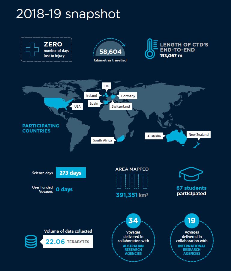
The 2018-19 voyage schedule hosted over 550 scientists, researchers and technical staff, including 67 students, from 34 Australian and 19 international institutions to deliver research at sea. The collaborative research supported by the Facility demonstrated the important capability that Investigator provides for Australia’s innovation system.
Science, Technology, Engineering and Mathematics (STEM) education and training continued to be a priority for the Facility. In 2019, the Collaborative Australian Postgraduate Sea Training Alliance Network (CAPSTAN) sailed for its second voyage, taking 27 students and trainers from 16 universities from Hobart to Fremantle. The CSIRO Educator on Board program hosted Australian teachers on voyages where they participated in research, ran ship-to-school outreach activities and developed curriculum-linked educational resources for use by all Australian teachers. Given MNF’s unique capability, we are committed to continuing to offer opportunities that support the development of future STEM professionals.
Finally, I would like to thank Dr Ian Poiner for his dedicated service to the MNF as Chair of the Steering Committee. Dr Poiner provided strategic leadership of the Committee during a critical period for the MNF which saw the Investigator built, commissioned and introduced into active service in 2014. Following this significant achievement, Dr Poiner was tireless in his efforts to promote the achievements of the Facility with key stakeholders and was instrumental in prosecuting the case for full-year funding secured via the May 2018 Government Budget.
I thank Ian for his years of service to the MNF and the wise counsel he has provided during his tenure. I wish him well in all his future endeavours.
2018 brought the appointment of a new MNF Facilities Program Director and I would like to take this opportunity to congratulate Dr Barbara Musso and welcome her to the MNF family. Dr Musso brings with her a wealth of experience in marine research and management that has already been of significant benefit in the governance, management and operation of the Facility. Finally, I would like to thank Mr Ben Rae, the MNF’s acting Facilities Program Director between 2016 and 2017, who provided invaluable leadership and contribution while we conducted the extensive recruitment process.
Ms Toni Moate
Director, Marine National Facility
Health, Safety and Environment
The marine environments in which we operate are often remote and inhospitable and present unique demands for the MNF’s management of health, safety and the environment (HSE). The MNF aspires to zero harm and is continuously seeking opportunities to improve systems, procedures and policies designed to ensure the safety of people on and around Investigator. People are at the heart of the MNF’s ability to deliver great research support and innovation to our customers.
With the health, safety and well-being of its people, partners, and the communities and environments in which we operate our highest priority, risk management is incorporated into all activities associated with voyage planning and delivery and forms an integral part of all operations.
MNF works closely with Investigator’s Ships Management Contractor to align both maritime and shore based regulatory requirements. In addition, MNF has focussed on developing a robust system of recording and reporting on all health, safety and environmental incidents to ensure transparency and accountability and support continuous improvement through a lesson learned program. Efforts to improve reporting in 2018-19 have focused on the definition and correct reporting of Medical Treatment Case (MTC)1 incidents. As a result, the Incident Snapshot reflects an increase in MTCs which, rather than cause for concern, is evidence of improved communication of this type of incident.
With the shift to full-year operations, fatigue management was also an area of focus in 2018-19. Consultation with key stakeholders suggested several initiatives for implementation including practical strategies for personnel working at sea as well as an awareness raising campaign.
No Lost Time Injuries were incurred during the 2018–19 financial year.
2017–18
2018–19
Lost Time Injury
0
0
Medical Treatment Case
1
10
First Aid Case
6
4
Illness
7
5
TOTAL
14
19
Environmental Incidents
2
0
Technical Incidents
13
13
Near Misses
9
7
TOTAL
24
20
Continuous improvement
Marine Application Planning System (MAPS)
MNF is undertaking a project to digitise the current resource intensive and manual voyage planning and delivery process. The project is well advanced and MAAS Software Engineering, based in the Netherlands, has been selected to develop the online tool. MAAS has a strong background in marine planning software, having delivered similar solutions as part of a Royal Netherlands Institute for Sea Research and Natural Environment Research Council (UK) software development collaboration designed to integrate the different aspects of equipment management and ship programming, to streamline and integrate the process of delivering research voyages.
With final testing and implementation of the system expected in time for the 2020 call for sea-time applications, the MNF anticipates that the system will transform the end user experience and deliver significant efficiencies to MNF operational teams tasked with voyage planning. These improvements build on the MNF’s customer service focus and are critical to address the challenges presented by full year operations.
2017–18
2018–19
Lost Time Injury
0
0
Medical Treatment Case
1
10
First Aid Case
6
4
Illness
7
5
Total
14
19
2018-19 snapshot
Full year funding announcement
The 2018-19 schedule marked the first year of full operations for the Marine National Facility (MNF) following the announcement by the Australian Government of additional funding under the National Collaborative Research Infrastructure Strategy (NCRIS). As a result, the MNF were able to supplement the 2018-19 schedule with meritorious projects from previous application rounds to deliver additional research of national benefit.
Acknowledging the significant opportunities and challenges presented by full year funding, the MNF Steering Committee (SC) commissioned an independent review of the MNF’s access framework. The scope of the review was to establish whether the existing MNF access guidelines and application assessment criteria remain fit for purpose in the context of full-year funding. The review concluded in May 2019 and the SC are in the process of considering recommendations and developing a response, which will be implemented through 2019-20.
Research delivered and supported
The 2018-19 year saw the Marine National Facility (MNF) deliver a broad spectrum of research. Projects related to constraining iron cycling in the East Australian Current and the most comprehensive assessment of the physical and biogeochemical structure of the Antarctic Circumpolar Current front to date. Participants developed 3D models of whale’s prey. We completed maritime surveys and heritage mapping in addition to support for education, training and outreach activities. All voyages contributed towards developing future workforce and technological capability and community engagement with our Facility.
MNF continued support for Integrated Marine Observing System (IMOS) national research infrastructure through deployment and recovery of Southern Ocean Time Series moorings and those located in the East Australian Current.
Critical knowledge gaps relating to the interaction between the topography and the Antarctic Circumpolar Current were addressed. Researches revisited the iconic Huon and Tasman Fracture Commonwealth Marine Reserves to investigate the status and recovery of deep-sea coral communities since the cessation of commercial fishing on seamounts in the 1960s. An Institute of Marine and Antarctic Studies-led voyage with a similar focus looked at the formation and evolution of the Tasmanian Seamount Chain.
Our strategic partnership continued with the Australian Hydrographic Office to survey the primary shipping route through Bass Strait. This voyage featured a complimentary project led by Heritage Victoria and the Australian National Maritime Museum to map historic shipwreck sites.
The national benefit delivered by these projects included:
supporting long-term monitoring of the transfer of heat and carbon into the Southern Ocean interior;
determining phytoplankton, nutrient and temperature gradients along the East Australian Current;
improving our understanding of the dynamics of Southern Ocean processes;
providing the first scientific understanding of biogeochemical, microbial and ecological processes in the newly proclaimed Abrolhos Commonwealth Marine Reserve;
detailed surveys of the primary shipping route through Bass Strait to facilitate safe navigation for international and coastal shipping; and
mapping historic shipwrecks to contribute to their ongoing supervision and preservation by state and federal agencies.
The longest voyage this year was a 49-day, 200,000 square kilometre investigation into how krill swarms affect the distribution, abundance and behaviour of whales in the Southern Ocean. Researchers tracked both blue whales and krill, using a range of technologies including sonobuoys, multibeam echosounders, and drones to photograph whales and collect samples of their blows. Over 300 hours of search effort led to 36 encounters with blue whales and 25 individuals identified. For the first time on an Australian research vessel, echo sounders were used to construct three-dimensional pictures of giant krill swarms. Several swarms extended over one kilometre in length and hundreds of metres across, containing many millions of krill. The voyage’s multidisciplinary research will contribute to the improvement of ecosystem-based management of the Antarctic krill fishery and the conservation of endangered species such as Antarctic blue whales.
Integrated with the busy research schedule was a sea trial at the start of the year to test and calibrate new and updated equipment and systems. Trials are essential for maintaining the cutting-edge capabilities of the vessel and ensuring safe operations at sea.
The year saw the schedule conclude with Investigator travelling to Singapore for its first 5 yearly dry dock maintenance appointment.
2018-19 Voyage Schedule
AUGUST 2018
Southern Ocean Time Series (SOTS) moorings for climate and carbon cycle studies southwest of Tasmania
A team of 20 scientists and support staff led by Chief Scientist, Dr Eric Schulz, Bureau of Meteorology, voyaged to the Southern Ocean in August 2018 as part of a multiyear
partnership between the Integrated Marine Observing System (IMOS) and the Marine National Facility (MNF) that delivers critical long time-series data from the Southern Ocean to global datasets. This data increases our understanding of Southern Ocean characteristics, variability and processes, information vital for informing ocean and climate modelling. SOTS is an Australian contribution to the international Ocean SITES global network of time series observatories and is one of the few comprehensive Southern Ocean sites globally.
Through our strategic partnership with IMOS, MNF is contributing to the national priority of understanding and adapting to climate variability and change.
SEPTEMBER – OCTOBER 2018
Iron inputs and cycling in the southern extension of the East Australian Current
Chief Scientist A/Prof Michael Ellwood, Australian National University, led a team on a 28-day voyage in southwest, southeast and northeast of Tasmania to study iron inputs and cycling in the southern extension of the East Australian Current (EAC). At its southern extent near Tasmania, the nutrient depleted but iron rich waters of the EAC mix with cool, nutrient rich, and iron depleted Southern Ocean waters. In spring, large phytoplankton blooms can be seen associated with the mingling of these waters. This research examines the relationship between production and nutrient supply in the modern ocean and improves our interpretation of past ocean records from the region. Changes to the EAC caused by climatic shifts will have implications on elemental cycling, production and local climate.
To understand the impact of climate on marine ecosystems, communities and industries, the MNF is supporting researchers to observe and model key regions responses to climate variability and change.
OCTOBER – NOVEMBER 2018
How does a standing meander SE of Tasmania brake the Antarctic Circumpolar Current?
Chief Scientist Prof Nathan Bindoff, Institute for Marine and Antarctic Studies, led a 32-day voyage to the Southern Ocean to study the Antarctic Circumpolar Current (ACC) and Southern Ocean’s capacity to absorb heat and carbon dioxide and how this may respond to climate variability and change. This voyage sought to better understand why the east-flowing ACC has remained constant despite westerly winds strengthening by 20% over the last two decades. This Voyage also supported 15 students, an artist and professional filmmaker (from Ocean Media Institute). The ACC connects the Atlantic, Pacific and Indian Oceans and serves as a principal pathway of exchange among them. It plays a disproportionately large role in our climate, allowing the ocean to absorb 93% of global warming, 65% of which is taken up in the Southern Ocean, and approximately 26% of anthropogenic carbon dioxide emissions. Understanding the ACC will be a key factor in how the climate changes due to rising levels of atmospheric carbon dioxide.
This is further evidence of MNF’s support for research that contributes to the national priority to understand and adapt to climate variability and change.
NOVEMBER – DECEMBER 2018
Status and recovery of deep-sea coral communities on seamounts in iconic Australian marine parks
Chief Scientist Dr Alan Williams, CSIRO, led a team of 51 participants on a 27-day voyage to study deep-sea coral communities on undersea mountains (‘seamounts’) in two Australian Marine Parks and three other sites off the Tasmanian/Victorian coast. The team mapped the extent of deep-sea coral reefs to determine how much of the reef area lies within marine parks. Measures of how the reefs have recovered from earlier trawling impacts since being protected in marine parks were also taken to improve our understanding of deep-sea biodiversity and changes in deep-sea coral communities following their protection from fishing. Australia’s protection of deep-sea coral reefs living on seamounts through inclusion in marine parks is an important step in marine conservation. Deep-sea coral reefs support highly diverse communities of seafloor organisms but are fragile and vulnerable to human disturbance – particularly by bottom trawling (fishing).
MNF’s support for this research delivers into the national priority to conserve our biodiversity and ecosystem health.
DECEMBER 2018 – JANUARY 2019
The Balleny mantle plume: understanding its role in Tasmania-Antarctic breakup
Chief Scientist Dr Joanne Whittaker, University of Tasmania, led 27 participants on a 14-day voyage to study the role of the Balleny mantle plume in the plate tectonic breakup between Australia and Antarctica. Rocks collected from the seamount chain stretching across the Tasman Sea will be used to examine seamount geology, history and origin. Samples from this voyage will be used to test the hypothesis that the Balleny plume is linked to the continental breakup between Tasmania (Australia) and Cape Adare (Antarctica) 30-50 million years ago and answer questions about the fundamental processes driving the plate tectonic motions that led to the separation of Australia and Antarctica. Two Australian secondary school teachers were also on this voyage under our Educator on Board Program (the fourth voyage in this program).
JANUARY – MARCH 2019
Availability of Antarctic krill to large predators and their role in Southern Ocean biogeochemical recycling
Chief Scientist Dr Mike Double, Australian Antarctic Division, led a team of 40 participants on a 46-day voyage to Antarctica to investigate the distribution and behaviour of the Antarctic blue whale, and its primary food source, Antarctic krill. This research includes the first field-based investigation of the controversial theory of iron-fertilisation by whales (via poo). A BBC camera team joined the voyage to film for Frozen Planet II. The outcomes of this research will inform development of management systems for expanding Antarctic krill fisheries and will contribute to the conservation of endangered species such as Antarctic blue whales.
MNF’s support for these outcomes delivers into national priorities to ensure food security and conserve our biodiversity and ecosystem health.
MARCH – APRIL 2019
Southern Ocean Time Series (SOTS): maintaining deep water moorings and ocean surveys
This voyage supported two projects: the deployment and recovery of SOTS automated moorings (Chief Scientist Tom Trull, CSIRO) and Subantarctic Biogeochemistry of Carbon and Iron (Chief Scientist Phil Boyd, IMAS). SOTS moorings provide important data about deep ocean currents and properties needed to monitor and understand the role of the ocean on climate and climate variability.
Additionally, surveys of the biogeochemical cycles of iron and carbon in the Southern Ocean increase our understanding of how variability in iron supply and recycling influences the productivity and export of carbon into the subantarctic ocean. SOTS is an Australian contribution to the international OceanSITES global network of time series observatories and is one of the few comprehensive Southern Ocean sites globally. Through both our strategic partnership with IMOS and our support for examining processes that control productivity, food-webs and cycles of elements in subantarctic environments, MNF is contributing to the national priority of understanding and adapting to climate variability and change.
APRIL 2019
Seafloor mapping and historic shipwreck surveys in Bass Strait
Chief Scientist Emily Jateff, Australian National Maritime Museum, led a team of 23 participants on a 12-day voyage to conduct seafloor mapping in Bass Strait for the Australian Hydrographic Office and historic shipwreck surveys for the Australian National Maritime Museum and Heritage Victoria (Victorian Government). These surveys assist in facilitating safe navigation for shipping and improve confidence for subsurface navigation in Bass Strait as well as effective management of cultural heritage sites, both delivering into the national priority to maintain marine sovereignty and security.
Chief Scientist A/Prof Leah Moore, University of Canberra, led the second Collaborative Australian Postgraduate Sea Training Alliance Network (CAPSTAN) voyage. CAPSTAN offers unique at-sea training opportunities for postgraduate students and trainers enrolled in Australian universities. CAPSTAN 02 focussed on a high productivity region of the Great Australian Bight, one of only two known blue whale feeding grounds in Australian waters, involving 20 students and 9 trainers from 16 Australian universities, representing all states and territories.
Of note, 19 of the 29 CAPSTAN participants were women. Investing in our future through education and training is a key component of the National Marine Science Plan (2015-2025), particularly developing marine science research training that is more quantitative, cross-disciplinary and congruent with industry and government needs. MNF is actively participating in this important goal for Australian marine science through our support for CAPSTAN.
MAY – JUNE 2019
Supporting IIOE-2: Everything from physics to fish with some whales on the side
Chief Scientist Prof Lynnath Beckley, Murdoch University, led a team of 40 participants on a 3000+km survey along the 110°E longitudinal line off the coast of Western Australia. The whole oceanic ecosystem was surveyed as part of Australia’s contribution to the UNESCO-led 2nd International Indian Ocean Expedition (IIOE-2). The voyage retraced part of the historic first IIOE – completed in 1963 – and collected data to examine the effects of climate change on the waters of the Indian Ocean. The data collected is expected to reveal the effects of climate change on the physics, chemistry and biology of the waters of the south-east Indian Ocean.
Sixty years ago, marine scientists aboard ships from 14 countries combined their efforts to explore the largest unknown area of earth, the deep waters and seabed of the Indian Ocean. This expedition generated a wealth of information and formed the basis of our scientific understanding about the Indian Ocean basin. In 2019, the Investigator retraced part of the 110°E line to reveal the effects of climate change on the physics, chemistry and biology of the waters of the south-east Indian Ocean. Multi-disciplinary monitoring of key regions and support for National Marine Baselines and Long-term Monitoring Programs to develop comprehensive assessments of our marine estate is a call to action in the National Marine Science Plan (2015-2025). MNF supports this call through targeted multi-disciplinary voyages such as the IIOE-2.
Voyage Spotlight
Putting deep ocean life on the map
Delivering research to better understand and sustainably manage resilient and valuable marine environments.
In late 2018, CSIRO led a collaborative research voyage on Investigator to survey deep-sea coral communities on undersea mountains (‘seamounts’) in and around marine reserves off southern Tasmania. The remoteness and technical challenges of deep-water research means knowledge of the distribution and ecology of these communities is limited, creating unique challenges for Australia’s marine reserve managers. Deep-sea coral communities are fragile and slow-growing, vulnerable to human activities and to changes in ocean temperatures and acidity. To help manage these risks there is an urgent need to map the location and biodiversity of deep-sea coral communities and learn more about their resilience.
Investigator’s flexible platform and capacity allowed an ambitious and novel program of research. The collaborative hub created by the MNF brought together researchers from national and international organisations including CSIRO, National Environmental Science Program Marine Biodiversity Hub, Australian Museum, Museums Victoria, Tasmanian Museum and Art Gallery, three Australian universities, Parks Australia, and New Zealand’s National Institute of Water and Atmospheric Research.
During the month-long voyage, a total of 45 seamounts were surveyed and 147 seabed transects completed using specialised deep-water cameras. Seamounts previously sampled 10 and 20 years ago – some impacted by bottom trawling and some now protected in marine reserves – were also surveyed, providing information about recovery and resilience of these communities. The technical expertise of MNF and ASP Ship Management technical staff, working in partnership with voyage researchers enabled the successful collection of high-resolution imagery of the coral communities across 200 km of transects. Biological specimens were collected during the voyage, along with other important oceanographic and bathymetric (seafloor mapping) data.
Investigator’s ability to offer real-time data streams were used to actively engage the public in the research. The voyage was an Australian first, being live-streamed 24/7 via CSIRO.au. This included vision from the deep tow camera surveys, providing a real-time window on life up to 2000 metres below the surface. Over 5000 viewers were given a front row seat to the research, creating a powerful tool for public engagement with marine research.
The voyage collected around 7 TB of data, including 60,000 stereo images and 300 hours of video for analysis. Investigator’s facilities allowed researchers to conduct a preliminary review and annotation of large volumes of the visual data, ensuring its availability for further analysis and use before the ship returned to port. All data collected is made freely available for anyone to access and use.
The outcomes of this research will be substantial, providing distribution data to map the extent of these globally-significant deep-sea coral communities. It will also provide world-first recovery and resilience data for the Australian government, particularly marine reserve managers, as well as other national and international bodies. Ultimately, the research is contributing to a national government and industry blueprint to cost-effectively monitor the marine environment and help sustainable management of our fisheries and food supplies.
The outcomes from this research will be incorporated into Australia’s State of the Environment reporting and provides a measure by which Australia can be compared and assessed internationally on its performance as custodians of the marine environment.
Communications and engagement
The MNF is committed to informing Australian’s about the research, education and training we deliver to demonstrate return on investment and ensure that decision makers at all levels – from individual citizens to government and industry – are well-informed.
The MNF collaborates widely with the marine research community to support the regular delivery of communications, education programs and engagement events that are relevant, accessible and engaging.
Communications spotlight
Uncovering SS Iron Crown
With a coastline dotted with undiscovered shipwrecks and less than twenty percent of the seafloor in Australia’s Exclusive Economic Zone (EEZ) mapped to a modern standard, Investigator has had plenty of opportunities to make interesting and significant discoveries. During a seafloor survey voyage to Bass Strait that included a program of surveys for historic shipwrecks in the region, the vessel made another important discovery when it located the SS Iron Crown, an Australian freighter sunk by a Japanese submarine during World War II.
Iron Crown was a 100m ore freighter that was sunk on 4 June 1942. The heavily loaded freighter was hit by a torpedo from a submarine and sank within 60 seconds. Of the 43 crew on board, 38 lives were lost, and their resting place had been unknown for 77 years until discovered by a collaborative team of maritime archaeologists onboard Investigator. The sinking of Iron Crown was one of Victoria’s worst maritime disasters in terms of loss of life.
The announcement of the discovery, coming just days before Anzac Day 2019, was of significant public interest and of importance to both the maritime and defence community. In the days following the announcement, several descendants and family of crew members on Iron Crown came forward to seek further information and express their appreciation for locating the vessel’s final resting place. The discovery received global media attention providing high levels of visibility for the important work done by the MNF and its collaborators to help protect and preserve Australia’s maritime heritage. National media coverage was achieved via all TV networks, radio, online and print, with over 500 conventional and social media mentions related to discovery with an estimated audience reach of over 7.5 million.
Data collected by Investigator and the research team will help form the basis for future protection and management of this historic shipwreck site.
Financial statement
Strong financial management is critical to ensuring the MNF remains viable, effective, and accountable for the expenditure of public funds.
2017/18
2018/19
$'000
$'000
Revenue
External Funding
691
4,472
Internal Funding
25,782
26,214
Total Revenue
26,473
30,686
Expenditure
Labour
6,127
8,378
Other Operating
19,783
19,614
Total Expenditure
25,910
25,910
Operating Result
563
2,693*
Capital
Capital expenditure
1,061
4,028*
* Includes $2,926,000 of externally funded capital expenditure.
Improving our capabilities
Each year, the MNF undertakes a process to identify, prioritise and plan capital investment to support and increase the capability of Investigator for the benefit of our users.
In 2018-19 the MNF spent $2.677 M on new and replacement scientific equipment, underway sensors and capability upgrades including significant upgrades to the core handling system, starboard aft crane and vertical sediment winch. New and replacement equipment procured during the year included a marine seismic acquisition system, split beam transceivers, an acoustic doppler current profiler, incubation tanks, a magnetometer and a 36-bottle CTD frame.
Capability case study
Enhanced core handling
The MNF has invested in a new core handler system on board Investigator to enable more capable deep coring activities. The new system includes a replacement starboard aft crane with greater lifting capacity and a reconfigured core handler and telescopic boom arrangement to ensure safe deployment of the coring system at sea. Part of the procurement also includes a new piston corer. The system will be used to retrieve core samples of up to 24 m in length from as deep as 7000 m, providing researchers the ability to determine the physical, chemical and biological makeup of ocean sediments and insights into past (up to millions of years) oceanic conditions, processes and ecosystems including ocean circulation, sea surface temperature, acidity and a variety of ocean biota.
The system configuration will be completed in early January 2020 and the commissioning is planned for May 2020. The new system will be deployed for research purposes in June 2020.
Looking to the future
MNF is in an exciting period of growth. We are now well positioned to meet the challenge of supporting full year operations. MNF will continue to facilitate research that delivers benefit for the nation by providing high quality support to the Australian marine research community.
In response to the significant changes brought about by the increase in annual operations, and to findings from the review of the access framework, the MNF, supported by the Steering Committee, has commenced development of a strategy – MNF 2030 - to consolidate and communicate the directions MNF will take over the next decade for maximising the value delivered through the utilisation of the Investigator and improving operations for researchers accessing our capabilities.
In parallel, MNF will deliver the Marine Application and Planning System (MAPS), an online integrated application and planning management system. This digital solution will simplify the application processes for voyage proponents and significantly streamline workflow and information management during both application and voyage planning.
In striving to increase access to STEM (science, technology, engineering and mathematics) education for Aboriginal and Torres Strait Islander students, MNF has developed an initiative for increasing indigenous engagement: the Indigenous Time at Sea Scholarship (ITSS). ITSS will offer Aboriginal and Torres Strait Islander university students the opportunity to participate in research voyages on Investigator. The first round of applications will open in the first quarter of 2019-20 with two students selected for each ITSS identified voyage. The program aims to equip students with skills and experience that will translate into employment opportunities in relevant marine sectors.
The ocean plays an influential role in the everyday lives, economy, health and well-being of all Australians and we are rightly proud to be the custodians of the third largest marine estate in the world.
Understanding and ultimately managing the diverse ecosystems and industries of this vast area is challenging and requires navigational, sampling and data collection capabilities fit to meet the diverse needs of users.
Funded by the Australian Government, owned and operated by CSIRO on behalf of the nation under the oversight of an independent Steering Committee, the Marine National Facility (MNF) provides a blue-water research capability to the Australian research community and their international collaborators. The MNF is made up of: the ocean class research vessel Investigator; a suite of scientific equipment and instrumentation; a collection of marine data collected since the MNF’s creation; and the expertise required to manage an ocean-going research platform and support vessel users.
The research delivered from MNF voyages provides critical information to directly support government, industry and other stakeholders in making evidence-based decisions to ensure the long-term viability and prosperity of the Australian marine environment and industries.
From the Chairperson
Dr Ian Poiner, Chairperson, MNF Steering Committee.
The 2018-19 schedule marked the first year of full operations for the Marine National Facility (MNF) following the welcome announcement by the Australian Government of additional funding under the National Collaborative Research Infrastructure Strategy (NCRIS). As a result, the MNF were able to supplement the 2018-19 schedule with meritorious projects from previous application rounds to deliver additional research of national benefit.
Acknowledging the significant opportunities and challenges presented by full year funding, the MNF Steering Committee (SC) commissioned an independent review of the MNF access framework. The scope of the review was to establish whether the existing MNF access guidelines and application assessment criteria remain fit for purpose in the context of full-year funding. The review concluded in May 2019 and the SC are in the process of considering recommendations and developing a response.
Operating out of Investigator’s home port of Hobart for the first three quarters of the 2018-19 schedule, voyages focused on delivering research in the Southern and Pacific Oceans for a range of Australian research institutions and their international collaborators.
MNF again provided a platform for major projects in the national interest, including those led by the Integrated Marine Observing System and the Australian Hydrographic Office.
Investigator finished the year in the Indian Ocean where it delivered the second International Indian Ocean Expedition (IIOE), a major global scientific program to engage the international scientific community in collaborative oceanographic and atmospheric research in the Indian Ocean. Investigator was purpose-built for this type of international collaborative effort, and it was fantastic to finish another year of successful research and discoveries with a project so prominent on the world stage.
Having spent 5 years serving on the SC as a member and then as Chair, I am proud to have been involved in the work of the MNF with a highlight of welcoming Investigator into service in 2014. I have had the privilege of serving with a dedicated group of SC members whose experience and diversity has delivered expert guidance with respect to MNF operations and strategy. Likewise, the contributions, dedication, and expertise of the respective Chairs and members of both the Scientific Advisory Committee and National Benefit Assessment Panel has ensured MNF schedules feature high quality research that delivers tangible benefits to the nation.
I take the opportunity to welcome the new SC Chair, Dr Sue Barrell, and wish her well in this exciting and rewarding role. Sue is eminently qualified and has a passion for marine research that will set the MNF in good stead in the coming years.
In closing, I would like to recognise the work and dedication of the MNF staff and the broader research community for their continued support and the consistently high-quality applications that maximise the impact of the Marine National Facility.
The Marine National Facility (MNF) welcomed additional government support announced as part of the May 2018 budget to provide funding for full-year operations, allowing maximum sea time for Investigator. Having developed a contingency plan in anticipation of the announcement, the MNF implemented a recruitment strategy to fill a new structure in 2018-19.
The revised structure recognised the greater risk profile presented by more days at sea and shorter port periods. This was addressed through engagement of additional Health, Safety and Environment (HSE) expertise, and forming a dedicated HSE team tasked with ensuring the safety of our people, participants and the environments in which we operate. Additional personnel were also recruited to support the increased obligations for voyage planning and delivery, and a dedicated MNF Facilities Team was created. With a new dedicated stream of capital funding delivered through the National Collaborative Research Infrastructure Strategy (NCRIS) funding, the Facilities Team will also be responsible for working with the research community to develop short-, mid- and long-term capital planning that ensures our capability remains world-class.
Implementation of the new structure has been an exercise in efficient and effective change management and a challenge that the MNF team has embraced, supporting continuity of exemplary voyage delivery and support. Recruitment activities delivered during the year have also seen significant expansion of the Engineering and Technology team providing engineering, data, IT and science expertise to support our voyages.
The 2018-19 voyage schedule hosted over 550 scientists, researchers and technical staff, including 67 students, from 34 Australian and 19 international institutions to deliver research at sea. The collaborative research supported by the Facility demonstrated the important capability that Investigator provides for Australia’s innovation system.
Science, Technology, Engineering and Mathematics (STEM) education and training continued to be a priority for the Facility. In 2019, the Collaborative Australian Postgraduate Sea Training Alliance Network (CAPSTAN) sailed for its second voyage, taking 27 students and trainers from 16 universities from Hobart to Fremantle. The CSIRO Educator on Board program hosted Australian teachers on voyages where they participated in research, ran ship-to-school outreach activities and developed curriculum-linked educational resources for use by all Australian teachers. Given MNF’s unique capability, we are committed to continuing to offer opportunities that support the development of future STEM professionals.
Finally, I would like to thank Dr Ian Poiner for his dedicated service to the MNF as Chair of the Steering Committee. Dr Poiner provided strategic leadership of the Committee during a critical period for the MNF which saw the Investigator built, commissioned and introduced into active service in 2014. Following this significant achievement, Dr Poiner was tireless in his efforts to promote the achievements of the Facility with key stakeholders and was instrumental in prosecuting the case for full-year funding secured via the May 2018 Government Budget.
I thank Ian for his years of service to the MNF and the wise counsel he has provided during his tenure. I wish him well in all his future endeavours.
2018 brought the appointment of a new MNF Facilities Program Director and I would like to take this opportunity to congratulate Dr Barbara Musso and welcome her to the MNF family. Dr Musso brings with her a wealth of experience in marine research and management that has already been of significant benefit in the governance, management and operation of the Facility. Finally, I would like to thank Mr Ben Rae, the MNF’s acting Facilities Program Director between 2016 and 2017, who provided invaluable leadership and contribution while we conducted the extensive recruitment process.
Ms Toni Moate
Director, Marine National Facility
Health, Safety and Environment
The marine environments in which we operate are often remote and inhospitable and present unique demands for the MNF’s management of health, safety and the environment (HSE). The MNF aspires to zero harm and is continuously seeking opportunities to improve systems, procedures and policies designed to ensure the safety of people on and around Investigator. People are at the heart of the MNF’s ability to deliver great research support and innovation to our customers.
With the health, safety and well-being of its people, partners, and the communities and environments in which we operate our highest priority, risk management is incorporated into all activities associated with voyage planning and delivery and forms an integral part of all operations.
MNF works closely with Investigator’s Ships Management Contractor to align both maritime and shore based regulatory requirements. In addition, MNF has focussed on developing a robust system of recording and reporting on all health, safety and environmental incidents to ensure transparency and accountability and support continuous improvement through a lesson learned program. Efforts to improve reporting in 2018-19 have focused on the definition and correct reporting of Medical Treatment Case (MTC)1 incidents. As a result, the Incident Snapshot reflects an increase in MTCs which, rather than cause for concern, is evidence of improved communication of this type of incident.
With the shift to full-year operations, fatigue management was also an area of focus in 2018-19. Consultation with key stakeholders suggested several initiatives for implementation including practical strategies for personnel working at sea as well as an awareness raising campaign.
No Lost Time Injuries were incurred during the 2018–19 financial year.
2017–18
2018–19
Lost Time Injury
0
0
Medical Treatment Case
1
10
First Aid Case
6
4
Illness
7
5
TOTAL
14
19
Environmental Incidents
2
0
Technical Incidents
13
13
Near Misses
9
7
TOTAL
24
20
Continuous improvement
Marine Application Planning System (MAPS)
MNF is undertaking a project to digitise the current resource intensive and manual voyage planning and delivery process. The project is well advanced and MAAS Software Engineering, based in the Netherlands, has been selected to develop the online tool. MAAS has a strong background in marine planning software, having delivered similar solutions as part of a Royal Netherlands Institute for Sea Research and Natural Environment Research Council (UK) software development collaboration designed to integrate the different aspects of equipment management and ship programming, to streamline and integrate the process of delivering research voyages.
With final testing and implementation of the system expected in time for the 2020 call for sea-time applications, the MNF anticipates that the system will transform the end user experience and deliver significant efficiencies to MNF operational teams tasked with voyage planning. These improvements build on the MNF’s customer service focus and are critical to address the challenges presented by full year operations.
2017–18
2018–19
Lost Time Injury
0
0
Medical Treatment Case
1
10
First Aid Case
6
4
Illness
7
5
Total
14
19
2018-19 snapshot
Full year funding announcement
The 2018-19 schedule marked the first year of full operations for the Marine National Facility (MNF) following the announcement by the Australian Government of additional funding under the National Collaborative Research Infrastructure Strategy (NCRIS). As a result, the MNF were able to supplement the 2018-19 schedule with meritorious projects from previous application rounds to deliver additional research of national benefit.
Acknowledging the significant opportunities and challenges presented by full year funding, the MNF Steering Committee (SC) commissioned an independent review of the MNF’s access framework. The scope of the review was to establish whether the existing MNF access guidelines and application assessment criteria remain fit for purpose in the context of full-year funding. The review concluded in May 2019 and the SC are in the process of considering recommendations and developing a response, which will be implemented through 2019-20.
Research delivered and supported
The 2018-19 year saw the Marine National Facility (MNF) deliver a broad spectrum of research. Projects related to constraining iron cycling in the East Australian Current and the most comprehensive assessment of the physical and biogeochemical structure of the Antarctic Circumpolar Current front to date. Participants developed 3D models of whale’s prey. We completed maritime surveys and heritage mapping in addition to support for education, training and outreach activities. All voyages contributed towards developing future workforce and technological capability and community engagement with our Facility.
MNF continued support for Integrated Marine Observing System (IMOS) national research infrastructure through deployment and recovery of Southern Ocean Time Series moorings and those located in the East Australian Current.
Critical knowledge gaps relating to the interaction between the topography and the Antarctic Circumpolar Current were addressed. Researches revisited the iconic Huon and Tasman Fracture Commonwealth Marine Reserves to investigate the status and recovery of deep-sea coral communities since the cessation of commercial fishing on seamounts in the 1960s. An Institute of Marine and Antarctic Studies-led voyage with a similar focus looked at the formation and evolution of the Tasmanian Seamount Chain.
Our strategic partnership continued with the Australian Hydrographic Office to survey the primary shipping route through Bass Strait. This voyage featured a complimentary project led by Heritage Victoria and the Australian National Maritime Museum to map historic shipwreck sites.
The national benefit delivered by these projects included:
supporting long-term monitoring of the transfer of heat and carbon into the Southern Ocean interior;
determining phytoplankton, nutrient and temperature gradients along the East Australian Current;
improving our understanding of the dynamics of Southern Ocean processes;
providing the first scientific understanding of biogeochemical, microbial and ecological processes in the newly proclaimed Abrolhos Commonwealth Marine Reserve;
detailed surveys of the primary shipping route through Bass Strait to facilitate safe navigation for international and coastal shipping; and
mapping historic shipwrecks to contribute to their ongoing supervision and preservation by state and federal agencies.
The longest voyage this year was a 49-day, 200,000 square kilometre investigation into how krill swarms affect the distribution, abundance and behaviour of whales in the Southern Ocean. Researchers tracked both blue whales and krill, using a range of technologies including sonobuoys, multibeam echosounders, and drones to photograph whales and collect samples of their blows. Over 300 hours of search effort led to 36 encounters with blue whales and 25 individuals identified. For the first time on an Australian research vessel, echo sounders were used to construct three-dimensional pictures of giant krill swarms. Several swarms extended over one kilometre in length and hundreds of metres across, containing many millions of krill. The voyage’s multidisciplinary research will contribute to the improvement of ecosystem-based management of the Antarctic krill fishery and the conservation of endangered species such as Antarctic blue whales.
Integrated with the busy research schedule was a sea trial at the start of the year to test and calibrate new and updated equipment and systems. Trials are essential for maintaining the cutting-edge capabilities of the vessel and ensuring safe operations at sea.
The year saw the schedule conclude with Investigator travelling to Singapore for its first 5 yearly dry dock maintenance appointment.
2018-19 Voyage Schedule
AUGUST 2018
Southern Ocean Time Series (SOTS) moorings for climate and carbon cycle studies southwest of Tasmania
Through our strategic partnership with IMOS, MNF is contributing to the national priority of understanding and adapting to climate variability and change.
SEPTEMBER – OCTOBER 2018
Iron inputs and cycling in the southern extension of the East Australian Current
Chief Scientist A/Prof Michael Ellwood, Australian National University, led a team on a 28-day voyage in southwest, southeast and northeast of Tasmania to study iron inputs and cycling in the southern extension of the East Australian Current (EAC). At its southern extent near Tasmania, the nutrient depleted but iron rich waters of the EAC mix with cool, nutrient rich, and iron depleted Southern Ocean waters. In spring, large phytoplankton blooms can be seen associated with the mingling of these waters. This research examines the relationship between production and nutrient supply in the modern ocean and improves our interpretation of past ocean records from the region. Changes to the EAC caused by climatic shifts will have implications on elemental cycling, production and local climate.
To understand the impact of climate on marine ecosystems, communities and industries, the MNF is supporting researchers to observe and model key regions responses to climate variability and change.
OCTOBER – NOVEMBER 2018
How does a standing meander SE of Tasmania brake the Antarctic Circumpolar Current?
Chief Scientist Prof Nathan Bindoff, Institute for Marine and Antarctic Studies, led a 32-day voyage to the Southern Ocean to study the Antarctic Circumpolar Current (ACC) and Southern Ocean’s capacity to absorb heat and carbon dioxide and how this may respond to climate variability and change. This voyage sought to better understand why the east-flowing ACC has remained constant despite westerly winds strengthening by 20% over the last two decades. This Voyage also supported 15 students, an artist and professional filmmaker (from Ocean Media Institute). The ACC connects the Atlantic, Pacific and Indian Oceans and serves as a principal pathway of exchange among them. It plays a disproportionately large role in our climate, allowing the ocean to absorb 93% of global warming, 65% of which is taken up in the Southern Ocean, and approximately 26% of anthropogenic carbon dioxide emissions. Understanding the ACC will be a key factor in how the climate changes due to rising levels of atmospheric carbon dioxide.
This is further evidence of MNF’s support for research that contributes to the national priority to understand and adapt to climate variability and change.
NOVEMBER – DECEMBER 2018
Status and recovery of deep-sea coral communities on seamounts in iconic Australian marine parks
Chief Scientist Dr Alan Williams, CSIRO, led a team of 51 participants on a 27-day voyage to study deep-sea coral communities on undersea mountains (‘seamounts’) in two Australian Marine Parks and three other sites off the Tasmanian/Victorian coast. The team mapped the extent of deep-sea coral reefs to determine how much of the reef area lies within marine parks. Measures of how the reefs have recovered from earlier trawling impacts since being protected in marine parks were also taken to improve our understanding of deep-sea biodiversity and changes in deep-sea coral communities following their protection from fishing. Australia’s protection of deep-sea coral reefs living on seamounts through inclusion in marine parks is an important step in marine conservation. Deep-sea coral reefs support highly diverse communities of seafloor organisms but are fragile and vulnerable to human disturbance – particularly by bottom trawling (fishing).
MNF’s support for this research delivers into the national priority to conserve our biodiversity and ecosystem health.
DECEMBER 2018 – JANUARY 2019
The Balleny mantle plume: understanding its role in Tasmania-Antarctic breakup
Chief Scientist Dr Joanne Whittaker, University of Tasmania, led 27 participants on a 14-day voyage to study the role of the Balleny mantle plume in the plate tectonic breakup between Australia and Antarctica. Rocks collected from the seamount chain stretching across the Tasman Sea will be used to examine seamount geology, history and origin. Samples from this voyage will be used to test the hypothesis that the Balleny plume is linked to the continental breakup between Tasmania (Australia) and Cape Adare (Antarctica) 30-50 million years ago and answer questions about the fundamental processes driving the plate tectonic motions that led to the separation of Australia and Antarctica. Two Australian secondary school teachers were also on this voyage under our Educator on Board Program (the fourth voyage in this program).
JANUARY – MARCH 2019
Availability of Antarctic krill to large predators and their role in Southern Ocean biogeochemical recycling
MNF’s support for these outcomes delivers into national priorities to ensure food security and conserve our biodiversity and ecosystem health.
MARCH – APRIL 2019
Southern Ocean Time Series (SOTS): maintaining deep water moorings and ocean surveys
This voyage supported two projects: the deployment and recovery of SOTS automated moorings (Chief Scientist Tom Trull, CSIRO) and Subantarctic Biogeochemistry of Carbon and Iron (Chief Scientist Phil Boyd, IMAS). SOTS moorings provide important data about deep ocean currents and properties needed to monitor and understand the role of the ocean on climate and climate variability.
Additionally, surveys of the biogeochemical cycles of iron and carbon in the Southern Ocean increase our understanding of how variability in iron supply and recycling influences the productivity and export of carbon into the subantarctic ocean. SOTS is an Australian contribution to the international OceanSITES global network of time series observatories and is one of the few comprehensive Southern Ocean sites globally. Through both our strategic partnership with IMOS and our support for examining processes that control productivity, food-webs and cycles of elements in subantarctic environments, MNF is contributing to the national priority of understanding and adapting to climate variability and change.
APRIL 2019
Seafloor mapping and historic shipwreck surveys in Bass Strait
Chief Scientist Emily Jateff, Australian National Maritime Museum, led a team of 23 participants on a 12-day voyage to conduct seafloor mapping in Bass Strait for the Australian Hydrographic Office and historic shipwreck surveys for the Australian National Maritime Museum and Heritage Victoria (Victorian Government). These surveys assist in facilitating safe navigation for shipping and improve confidence for subsurface navigation in Bass Strait as well as effective management of cultural heritage sites, both delivering into the national priority to maintain marine sovereignty and security.
Of note, 19 of the 29 CAPSTAN participants were women. Investing in our future through education and training is a key component of the National Marine Science Plan (2015-2025), particularly developing marine science research training that is more quantitative, cross-disciplinary and congruent with industry and government needs. MNF is actively participating in this important goal for Australian marine science through our support for CAPSTAN.
MAY – JUNE 2019
Supporting IIOE-2: Everything from physics to fish with some whales on the side
Chief Scientist Prof Lynnath Beckley, Murdoch University, led a team of 40 participants on a 3000+km survey along the 110°E longitudinal line off the coast of Western Australia. The whole oceanic ecosystem was surveyed as part of Australia’s contribution to the UNESCO-led 2nd International Indian Ocean Expedition (IIOE-2). The voyage retraced part of the historic first IIOE – completed in 1963 – and collected data to examine the effects of climate change on the waters of the Indian Ocean. The data collected is expected to reveal the effects of climate change on the physics, chemistry and biology of the waters of the south-east Indian Ocean.
Sixty years ago, marine scientists aboard ships from 14 countries combined their efforts to explore the largest unknown area of earth, the deep waters and seabed of the Indian Ocean. This expedition generated a wealth of information and formed the basis of our scientific understanding about the Indian Ocean basin. In 2019, the Investigator retraced part of the 110°E line to reveal the effects of climate change on the physics, chemistry and biology of the waters of the south-east Indian Ocean. Multi-disciplinary monitoring of key regions and support for National Marine Baselines and Long-term Monitoring Programs to develop comprehensive assessments of our marine estate is a call to action in the National Marine Science Plan (2015-2025). MNF supports this call through targeted multi-disciplinary voyages such as the IIOE-2.
Voyage Spotlight
Putting deep ocean life on the map
Delivering research to better understand and sustainably manage resilient and valuable marine environments.
In late 2018, CSIRO led a collaborative research voyage on Investigator to survey deep-sea coral communities on undersea mountains (‘seamounts’) in and around marine reserves off southern Tasmania. The remoteness and technical challenges of deep-water research means knowledge of the distribution and ecology of these communities is limited, creating unique challenges for Australia’s marine reserve managers. Deep-sea coral communities are fragile and slow-growing, vulnerable to human activities and to changes in ocean temperatures and acidity. To help manage these risks there is an urgent need to map the location and biodiversity of deep-sea coral communities and learn more about their resilience.
Investigator’s flexible platform and capacity allowed an ambitious and novel program of research. The collaborative hub created by the MNF brought together researchers from national and international organisations including CSIRO, National Environmental Science Program Marine Biodiversity Hub, Australian Museum, Museums Victoria, Tasmanian Museum and Art Gallery, three Australian universities, Parks Australia, and New Zealand’s National Institute of Water and Atmospheric Research.
During the month-long voyage, a total of 45 seamounts were surveyed and 147 seabed transects completed using specialised deep-water cameras. Seamounts previously sampled 10 and 20 years ago – some impacted by bottom trawling and some now protected in marine reserves – were also surveyed, providing information about recovery and resilience of these communities. The technical expertise of MNF and ASP Ship Management technical staff, working in partnership with voyage researchers enabled the successful collection of high-resolution imagery of the coral communities across 200 km of transects. Biological specimens were collected during the voyage, along with other important oceanographic and bathymetric (seafloor mapping) data.
Investigator’s ability to offer real-time data streams were used to actively engage the public in the research. The voyage was an Australian first, being live-streamed 24/7 via CSIRO.au. This included vision from the deep tow camera surveys, providing a real-time window on life up to 2000 metres below the surface. Over 5000 viewers were given a front row seat to the research, creating a powerful tool for public engagement with marine research.
The outcomes of this research will be substantial, providing distribution data to map the extent of these globally-significant deep-sea coral communities. It will also provide world-first recovery and resilience data for the Australian government, particularly marine reserve managers, as well as other national and international bodies. Ultimately, the research is contributing to a national government and industry blueprint to cost-effectively monitor the marine environment and help sustainable management of our fisheries and food supplies.
The outcomes from this research will be incorporated into Australia’s State of the Environment reporting and provides a measure by which Australia can be compared and assessed internationally on its performance as custodians of the marine environment.
Communications and engagement
The MNF is committed to informing Australian’s about the research, education and training we deliver to demonstrate return on investment and ensure that decision makers at all levels – from individual citizens to government and industry – are well-informed.
The MNF collaborates widely with the marine research community to support the regular delivery of communications, education programs and engagement events that are relevant, accessible and engaging.
Communications spotlight
Uncovering SS Iron Crown
With a coastline dotted with undiscovered shipwrecks and less than twenty percent of the seafloor in Australia’s Exclusive Economic Zone (EEZ) mapped to a modern standard, Investigator has had plenty of opportunities to make interesting and significant discoveries. During a seafloor survey voyage to Bass Strait that included a program of surveys for historic shipwrecks in the region, the vessel made another important discovery when it located the SS Iron Crown, an Australian freighter sunk by a Japanese submarine during World War II.
Iron Crown was a 100m ore freighter that was sunk on 4 June 1942. The heavily loaded freighter was hit by a torpedo from a submarine and sank within 60 seconds. Of the 43 crew on board, 38 lives were lost, and their resting place had been unknown for 77 years until discovered by a collaborative team of maritime archaeologists onboard Investigator. The sinking of Iron Crown was one of Victoria’s worst maritime disasters in terms of loss of life.
The announcement of the discovery, coming just days before Anzac Day 2019, was of significant public interest and of importance to both the maritime and defence community. In the days following the announcement, several descendants and family of crew members on Iron Crown came forward to seek further information and express their appreciation for locating the vessel’s final resting place. The discovery received global media attention providing high levels of visibility for the important work done by the MNF and its collaborators to help protect and preserve Australia’s maritime heritage. National media coverage was achieved via all TV networks, radio, online and print, with over 500 conventional and social media mentions related to discovery with an estimated audience reach of over 7.5 million.
Data collected by Investigator and the research team will help form the basis for future protection and management of this historic shipwreck site.
Financial statement
Strong financial management is critical to ensuring the MNF remains viable, effective, and accountable for the expenditure of public funds.
2017/18
2018/19
$'000
$'000
Revenue
External Funding
691
4,472
Internal Funding
25,782
26,214
Total Revenue
26,473
30,686
Expenditure
Labour
6,127
8,378
Other Operating
19,783
19,614
Total Expenditure
25,910
25,910
Operating Result
563
2,693*
Capital
Capital expenditure
1,061
4,028*
* Includes $2,926,000 of externally funded capital expenditure.
Improving our capabilities
Each year, the MNF undertakes a process to identify, prioritise and plan capital investment to support and increase the capability of Investigator for the benefit of our users.
In 2018-19 the MNF spent $2.677 M on new and replacement scientific equipment, underway sensors and capability upgrades including significant upgrades to the core handling system, starboard aft crane and vertical sediment winch. New and replacement equipment procured during the year included a marine seismic acquisition system, split beam transceivers, an acoustic doppler current profiler, incubation tanks, a magnetometer and a 36-bottle CTD frame.
Capability case study
Enhanced core handling
The MNF has invested in a new core handler system on board Investigator to enable more capable deep coring activities. The new system includes a replacement starboard aft crane with greater lifting capacity and a reconfigured core handler and telescopic boom arrangement to ensure safe deployment of the coring system at sea. Part of the procurement also includes a new piston corer. The system will be used to retrieve core samples of up to 24 m in length from as deep as 7000 m, providing researchers the ability to determine the physical, chemical and biological makeup of ocean sediments and insights into past (up to millions of years) oceanic conditions, processes and ecosystems including ocean circulation, sea surface temperature, acidity and a variety of ocean biota.
The system configuration will be completed in early January 2020 and the commissioning is planned for May 2020. The new system will be deployed for research purposes in June 2020.
Looking to the future
MNF is in an exciting period of growth. We are now well positioned to meet the challenge of supporting full year operations. MNF will continue to facilitate research that delivers benefit for the nation by providing high quality support to the Australian marine research community.
In parallel, MNF will deliver the Marine Application and Planning System (MAPS), an online integrated application and planning management system. This digital solution will simplify the application processes for voyage proponents and significantly streamline workflow and information management during both application and voyage planning.
In striving to increase access to STEM (science, technology, engineering and mathematics) education for Aboriginal and Torres Strait Islander students, MNF has developed an initiative for increasing indigenous engagement: the Indigenous Time at Sea Scholarship (ITSS). ITSS will offer Aboriginal and Torres Strait Islander university students the opportunity to participate in research voyages on Investigator. The first round of applications will open in the first quarter of 2019-20 with two students selected for each ITSS identified voyage. The program aims to equip students with skills and experience that will translate into employment opportunities in relevant marine sectors.
We have received your enquiry and will reply soon.
We're Sorry
The contact form is currently unavailable. Please try again later. If this problem persists, please call us with your enquiry on 1300 363 400 or +61 3 9545 2176. We are available from 9.00 am to 4.00 pm AEST Monday - Friday.
 Australia's world-class marine research capability
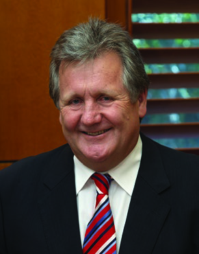

 The 2018-19 year saw the Marine National Facility (MNF) deliver a broad spectrum of research. Projects related to constraining iron cycling in the East Australian Current and the most comprehensive assessment of the physical and biogeochemical structure of the Antarctic Circumpolar Current front to date. Participants developed 3D models of whale’s prey. We completed maritime surveys and heritage mapping in addition to support for education, training and outreach activities. All voyages contributed towards developing future workforce and technological capability and community engagement with our Facility.
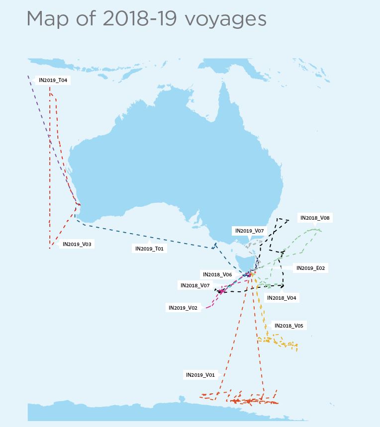
 A team of 20 scientists and support staff led by Chief Scientist, Dr Eric Schulz, Bureau of Meteorology, voyaged to the Southern Ocean in August 2018 as part of a multiyear
 Chief Scientist Prof Nathan Bindoff, Institute for Marine and Antarctic Studies, led a 32-day voyage to the Southern Ocean to study the Antarctic Circumpolar Current (ACC) and Southern Ocean’s capacity to absorb heat and carbon dioxide and how this may respond to climate variability and change. This voyage sought to better understand why the east-flowing ACC has remained constant despite westerly winds strengthening by 20% over the last two decades. This Voyage also supported 15 students, an artist and professional filmmaker (from Ocean Media Institute). The ACC connects the Atlantic, Pacific and Indian Oceans and serves as a principal pathway of exchange among them. It plays a disproportionately large role in our climate, allowing the ocean to absorb 93% of global warming, 65% of which is taken up in the Southern Ocean, and approximately 26% of anthropogenic carbon dioxide emissions. Understanding the ACC will be a key factor in how the climate changes due to rising levels of atmospheric carbon dioxide.
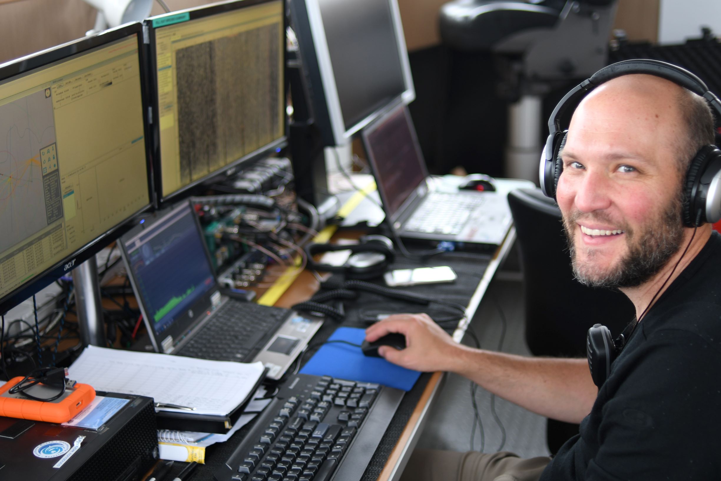 Chief Scientist Dr Mike Double, Australian Antarctic Division, led a team of 40 participants on a 46-day voyage to Antarctica to investigate the distribution and behaviour of the Antarctic blue whale, and its primary food source, Antarctic krill. This research includes the first field-based investigation of the controversial theory of iron-fertilisation by whales (via poo). A BBC camera team joined the voyage to film for Frozen Planet II. The outcomes of this research will inform development of management systems for expanding Antarctic krill fisheries and will contribute to the conservation of endangered species such as Antarctic blue whales.
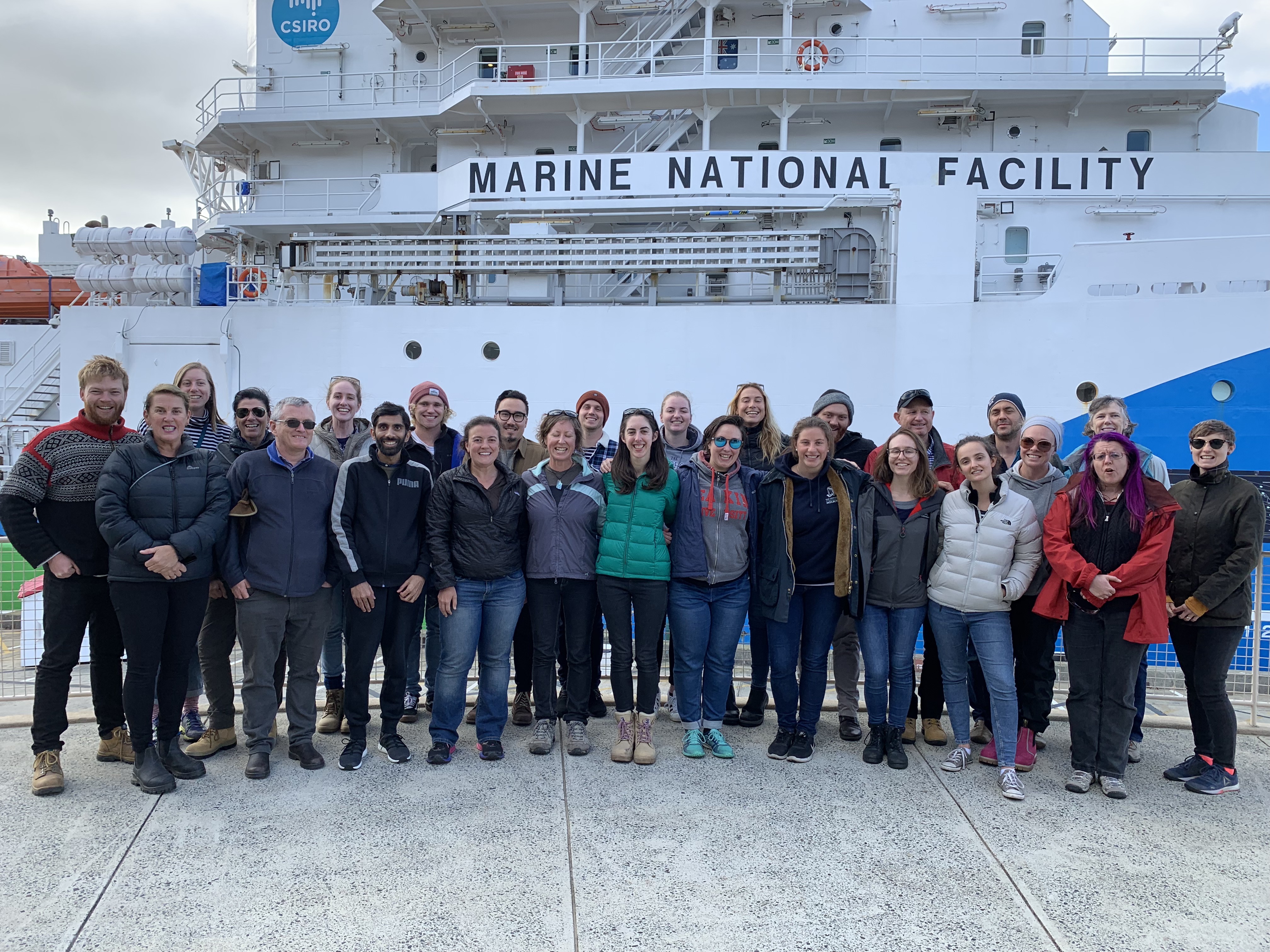 Chief Scientist A/Prof Leah Moore, University of Canberra, led the second Collaborative Australian Postgraduate Sea Training Alliance Network (CAPSTAN) voyage. CAPSTAN offers unique at-sea training opportunities for postgraduate students and trainers enrolled in Australian universities. CAPSTAN 02 focussed on a high productivity region of the Great Australian Bight, one of only two known blue whale feeding grounds in Australian waters, involving 20 students and 9 trainers from 16 Australian universities, representing all states and territories.
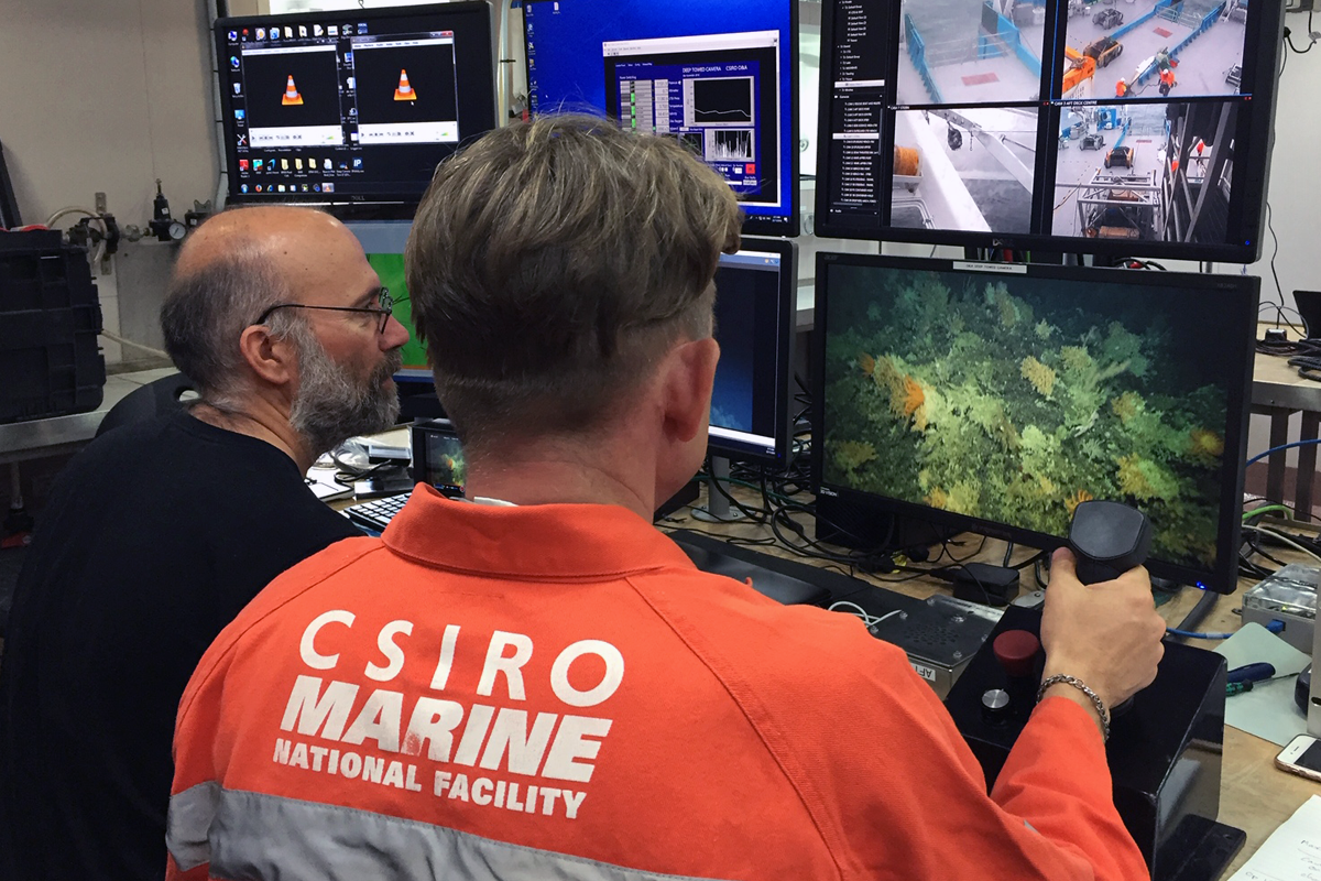 In late 2018, CSIRO led a collaborative research voyage on Investigator to survey deep-sea coral communities on undersea mountains (‘seamounts’) in and around marine reserves off southern Tasmania. The remoteness and technical challenges of deep-water research means knowledge of the distribution and ecology of these communities is limited, creating unique challenges for Australia’s marine reserve managers. Deep-sea coral communities are fragile and slow-growing, vulnerable to human activities and to changes in ocean temperatures and acidity. To help manage these risks there is an urgent need to map the location and biodiversity of deep-sea coral communities and learn more about their resilience.
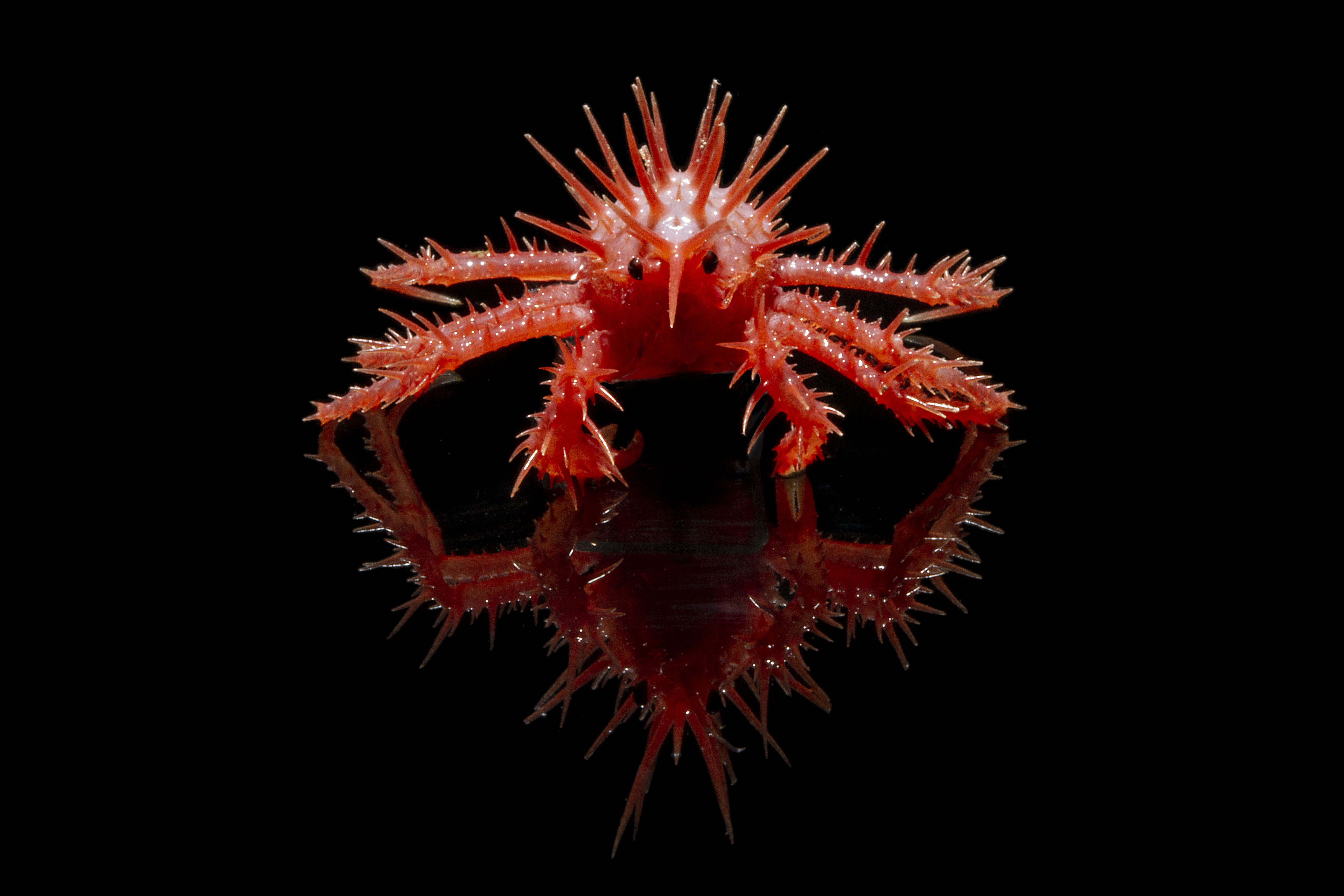 The voyage collected around 7 TB of data, including 60,000 stereo images and 300 hours of video for analysis. Investigator’s facilities allowed researchers to conduct a preliminary review and annotation of large volumes of the visual data, ensuring its availability for further analysis and use before the ship returned to port. All data collected is made freely available for anyone to access and use.
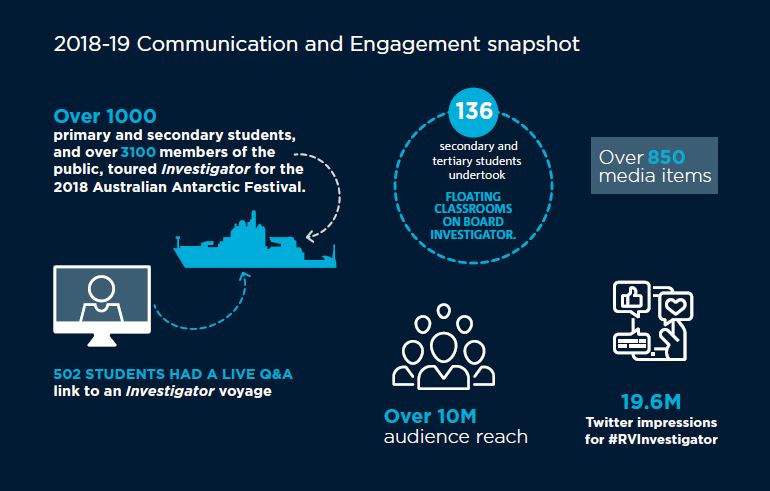
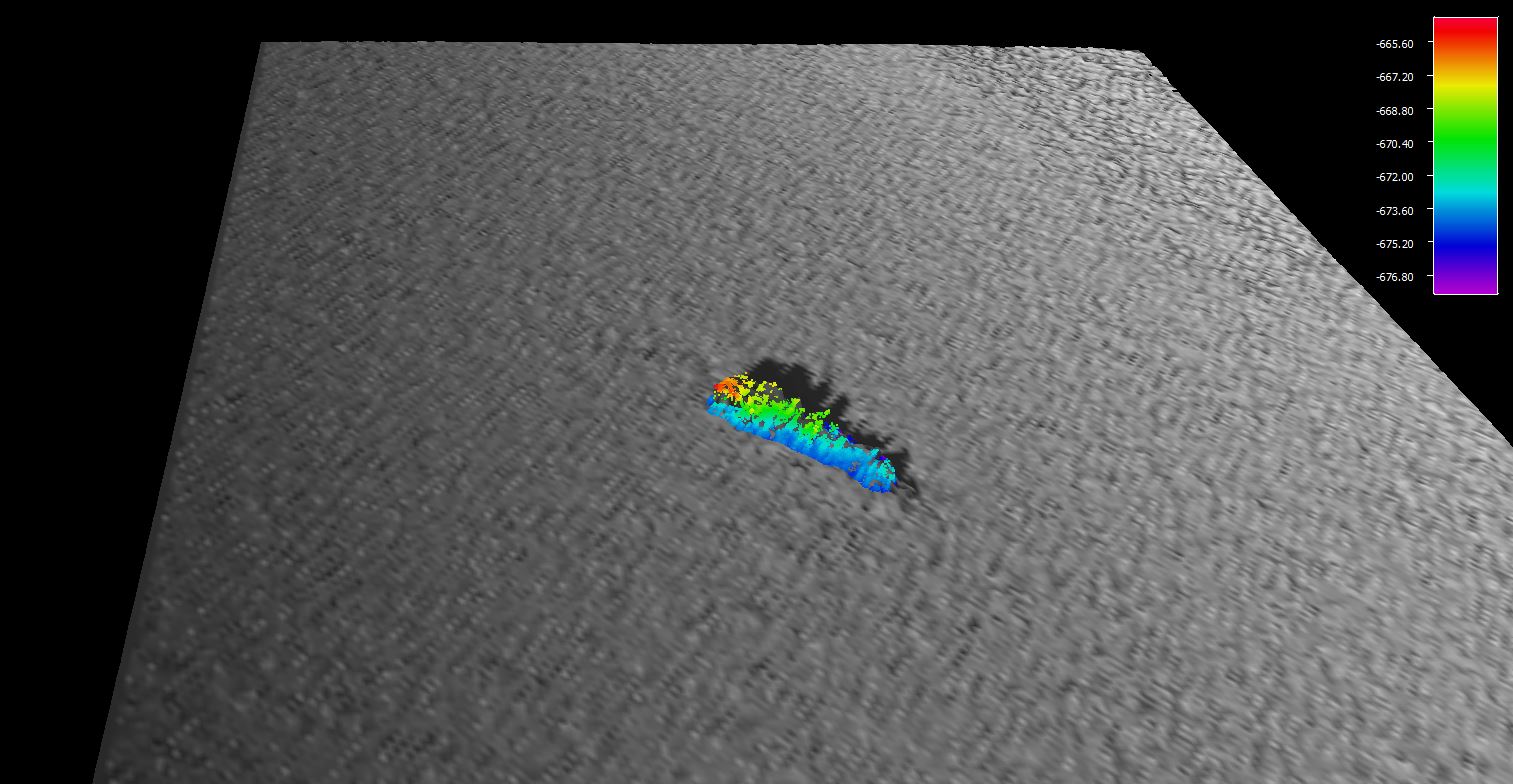 With a coastline dotted with undiscovered shipwrecks and less than twenty percent of the seafloor in Australia’s Exclusive Economic Zone (EEZ) mapped to a modern standard, Investigator has had plenty of opportunities to make interesting and significant discoveries. During a seafloor survey voyage to Bass Strait that included a program of surveys for historic shipwrecks in the region, the vessel made another important discovery when it located the SS Iron Crown, an Australian freighter sunk by a Japanese submarine during World War II.
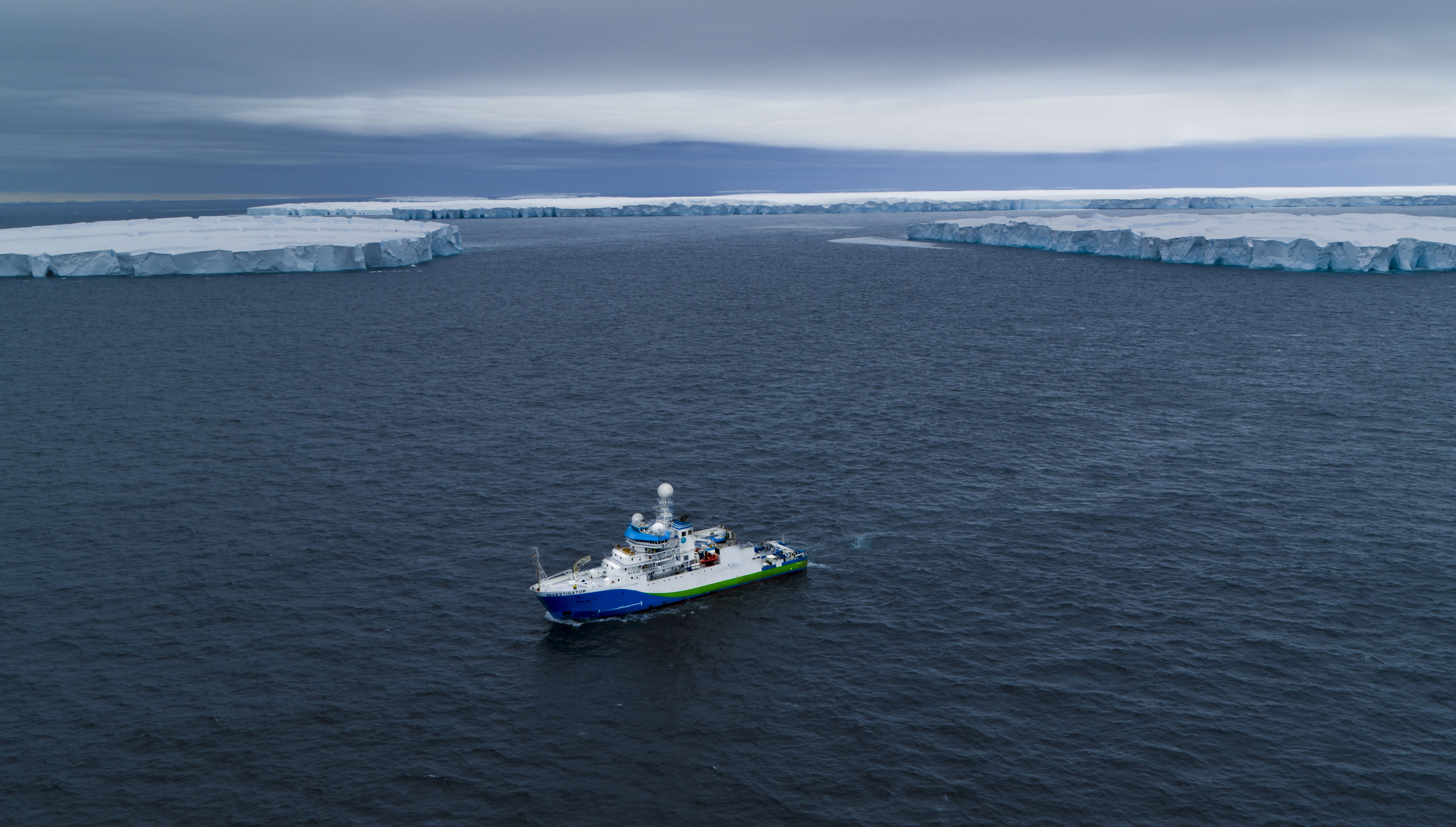 Each year, the MNF undertakes a process to identify, prioritise and plan capital investment to support and increase the capability of Investigator for the benefit of our users.
 In response to the significant changes brought about by the increase in annual operations, and to findings from the review of the access framework, the MNF, supported by the Steering Committee, has commenced development of a strategy – MNF 2030 - to consolidate and communicate the directions MNF will take over the next decade for maximising the value delivered through the utilisation of the Investigator and improving operations for researchers accessing our capabilities.


