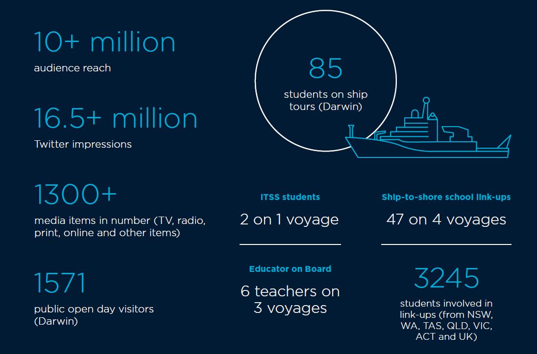
Download the Annual Report 2019-20:
Marine National Facility
Annual Report 2019-20
Australia's world-class marine research capability
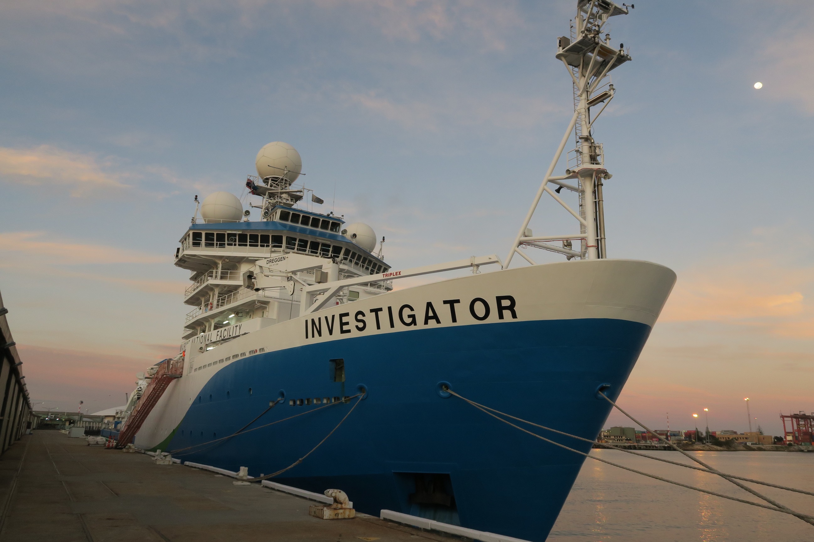
Australia has jurisdiction over the third largest marine estate in the world and our ocean territory contains a wide diversity of habitats. The Marine National Facility (MNF) provides a blue-water research capability to the Australian research community and their international collaborators to study this immense and diverse area.
The MNF is funded by the Australian Government and owned and operated by CSIRO on behalf of the nation. It includes the multidisciplinary Research Vessel (RV) Investigator, a suite of scientific equipment, technical staff and expertise, and more than 35 years of freely available marine data.
RV Investigator can accommodate a science team of 40 participants and can be at sea for up to 60 days and cover 10,000 nautical miles per voyage, operating anywhere from the Antarctic ice edge to the tropics. RV Investigator has been purpose built to meet the needs of Australian marine researchers as a highly capable platform for multidisciplinary research, including geology and geophysics, biology, biogeochemistry, climate and meteorology.
The research conducted on MNF voyages provides important information that supports evidence-based decision-making by government, industry and other stakeholders. Our goal is to enhance the long-term viability and prosperity of the Australian marine environment, industries and community. In doing so we strive to facilitate safe, efficient and excellent marine and atmospheric research that addresses the challenges that Australia faces, now and into the future.
From the Chairperson
There has never been a more important time to have a solid strategy combined with an eye on the future to help navigate the impacts of a worldwide pandemic on the operations of the Marine National Facility (MNF). In 2019–20, the MNF was scheduled to deliver 303 days of merit‑based research. The impact of the COVID-19 pandemic, however, led to the MNF taking proactive health and safety measures and imposing restrictions on operations. Most significantly, travel restrictions caused significant disruption for a facility that provides an international hub for collaboration in research.
Alongside the halt of operations caused by the pandemic, the 2019–20 year saw the development of the MNF 2030 strategy, which maps out an ambitious course for the MNF over the next decade. The strategy describes the directions the MNF will take in the pursuit of operational excellence, capability improvements, and education and outreach opportunities. The strategy also introduces improvements in the way researchers can access time on RV Investigator and in annual scheduling of activities.
The Australian Government, through the CSIRO and the National Collaborative Research Infrastructure Strategy, funds the MNF to operate RV Investigator to deliver a full-year research program. The strategic objectives and key actions outlined in the new strategy are intended to keep us on course to fulfil our mission to facilitate safe, efficient and excellent marine and atmospheric research that has national benefit and actively promotes clear alignment with government and industry priorities.
In looking to the future and based on the experience of the MNF team, I believe that increased public benefit and broader access will be delivered by taking a more active role in managing science capabilities through the new strategy.
This annual report tells many stories of the value we are delivering to our partners and across industry, government and the research community, as well as to every Australian. The RV Investigator continued to prove it is a highly capable, multi-purpose, dedicated research platform that enables researchers to address Australia’s most pressing challenges. This is achieved in some of the most remote and wild reaches of the global ocean. The impact of COVID-19 has not lessened the impact of the research that continues to be conducted by the MNF, to benefit Australia and the world.
Everything the MNF does is driven by our extraordinary and committed team members. I want to thank the whole MNF team for their commitment and dedication during the unexpected events of this year.
Dr Sue Barrell
Chairperson, MNF Steering Committee
From the Director
It was only last year that the Marine National Facility (MNF) started full year operations and the 2019–20 year was set to deliver approximately 300 days at sea. Though the MNF chose to suspend operations for a period as a result of the impact of the pandemic, the MNF team has performed remarkably well given the hardships COVID-19 has brought with it.
I look back on all that the MNF has achieved this year, given the extraordinary circumstances facing its operations, and believe our people have shown what a critical part they play in ensuring Australia’s future sustainability, prosperity and security. Over 2019–20, members of the MNF worked strategically and closely with those affected by the hold on operations to identify options for rescheduling of research projects and in planning to accommodate competing demands of both research and maintenance.
The MNF was still able to deliver a wide range of research in 2019–20 and, though originally scheduling seven research voyages to take place, the impact of COVID-19 and the proactive health and safety measures employed by the MNF meant there were less than planned. Even with the significant challenges faced, the MNF was able to successfully deliver four research voyages, one sea trial and three transit voyages, as well as delivering the first of the mandatory 5-year dry docks for the vessel.
RV Investigator this year hosted researchers who studied the origin and development of two remote submarine plateaus in the Southern Ocean. The data collected from this voyage will inform a submission to the United Nations that may lead to Australia’s marine jurisdiction being extended by an area the size of Switzerland. This research helps Australia maintain a secure and prosperous maritime territory.
During 2019–20, the MNF exhibited our ongoing commitment to educating and training Australia’s next generation of marine researchers, including supporting participation in research by Aboriginal and Torres Strait Islander peoples. The MNF launched the Indigenous Time at Sea Scholarship to increase opportunities for Aboriginal and Torres Strait Islands university students to participate in the management of the marine environment and develop the STEM skills critical for Australia’s future workforce. The benefits of the experience and mentoring received by students during voyages is long lasting and a critical investment for Australia’s future marine industries.
The voyages that took place in 2019–20 exemplify the multi-disciplinary research that RV Investigator makes possible. From gathering data by the mapping of submarine canyons and landslides along the margin of the Great Barrier Reef, uncovering the location of WWII shipwrecks and investigation into deep mantle plumes that influenced the evolution of the Australian plate, 2019–20 was a productive year.
I would like to extend my heartfelt thanks to the staff in the MNF team, the Engineering and Technology Team that supports the technical operations, and the Crew from ASP Ship Management for their work and flexibility that made it possible for the ship to return to sea safely this year.
Toni Moate
Director, Marine National Facility
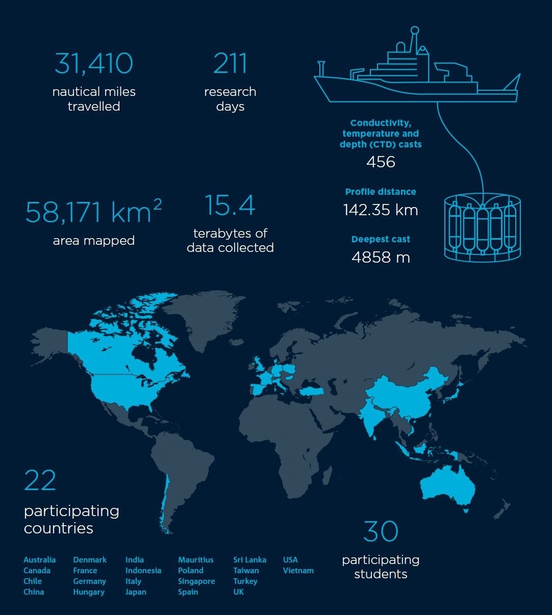
2019-20 snapshot
COVID-19 implications and measures
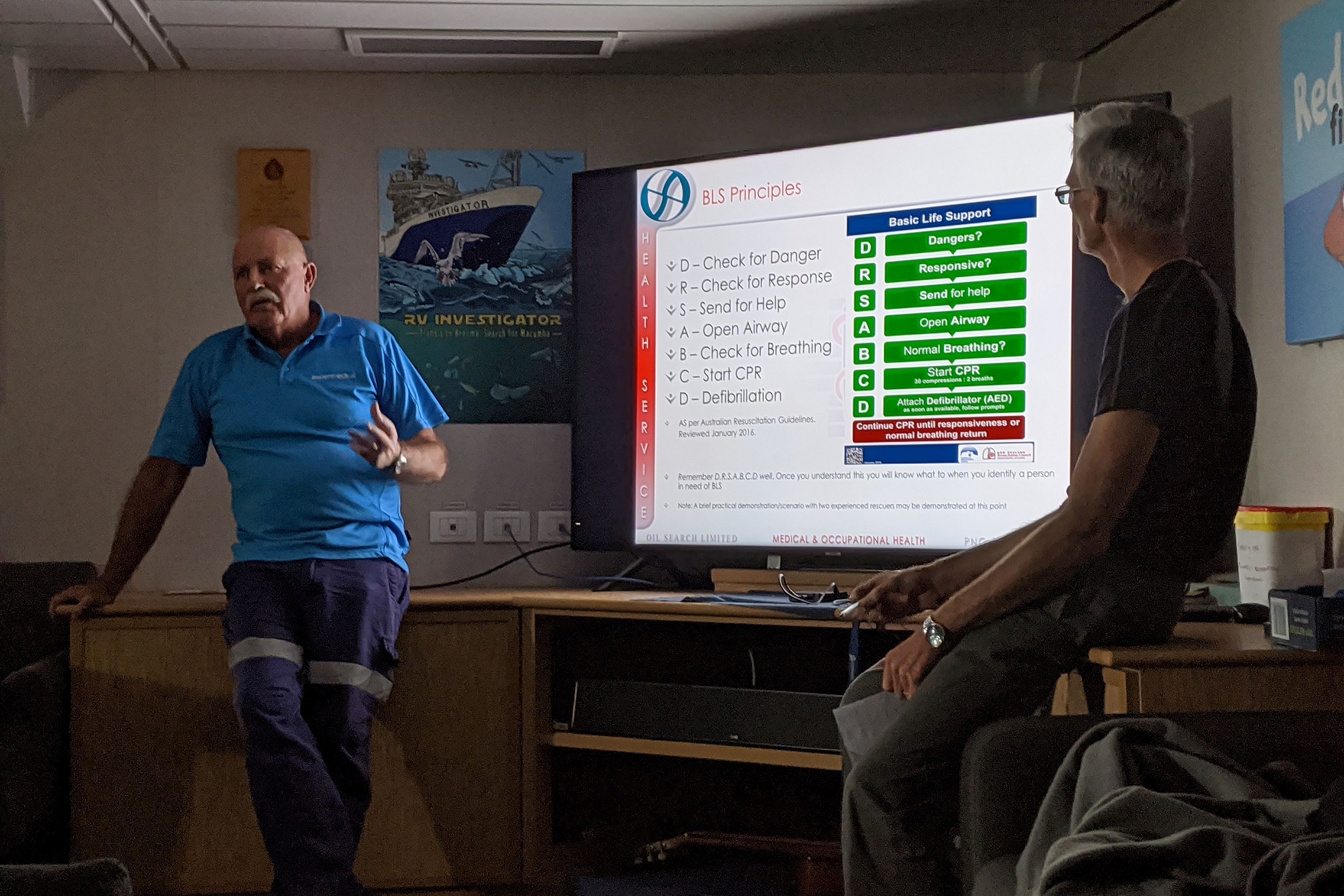
The 2019–20 period presented a particularly challenging landscape for the delivery of at-sea research with the global COVID-19 pandemic having a significant impact on MNF operations. Paramount in decision making about MNF operations is the health and wellbeing of our people, partners and the community so, based on available medical advice and assessment of the situation, the MNF acted decisively in early 2020 and took proactive measures to safeguard health and prevent spread of COVID-19.
The MNF was initially scheduled for continuation of full‑year operations and the delivery of 303 research days in the planned voyage schedule. The impact of the COVID-19 pandemic, including travel restrictions affecting movement of people and cargo, necessitated that the MNF cancel voyages and reschedule research projects.
At-sea operations of RV Investigator were suspended during March 2020 and the ship returned to its home port of Hobart, Tasmania. At-sea operations did not resume during 2019–20. The suspension of operations resulted in one voyage being cancelled, and five others being rescheduled. These disruptions led to numerous other flow-on impacts to the future research schedule.
The MNF worked closely with those affected by this unavoidable disruption to the voyage schedule in order to identify options for rescheduling of research projects, as well as manage the competing demands of research and vessel maintenance. The disruption also impacted on the planned education, training and outreach programs of the MNF, with the cancellation of numerous activities and events.
In response to the COVID-19 pandemic and its impact, the MNF commenced development of a framework to safely and efficiently manage operations under a set of modified operating protocols. These protocols were designed to safeguard the safety and wellbeing of those on board while enabling the successful resumption of at-sea operations in a global environment where COVID-19 persisted. While the situation remained unpredictable at the conclusion of the period, the response framework and planning are well underway to enable a safe and effective restart of at-sea operations early in the new financial year.
The MNF Steering Committee endorses a voyage schedule for each financial year that allocates approximately 300 days of project time on RV Investigator to research proposals that are deemed meritorious in the application process. Historically, the MNF has achieved or exceeded targets set for allocation of sea time. In 2019–20 and in spite of significant disruptions to operations, the MNF was still able to successfully deliver 70 per cent of the allocated 303 research days, with only 92 of planned research days not being delivered due to the impact of the COVID-19 pandemic.
Research delivered and supported
The MNF delivered a wide range of research in 2019–20.
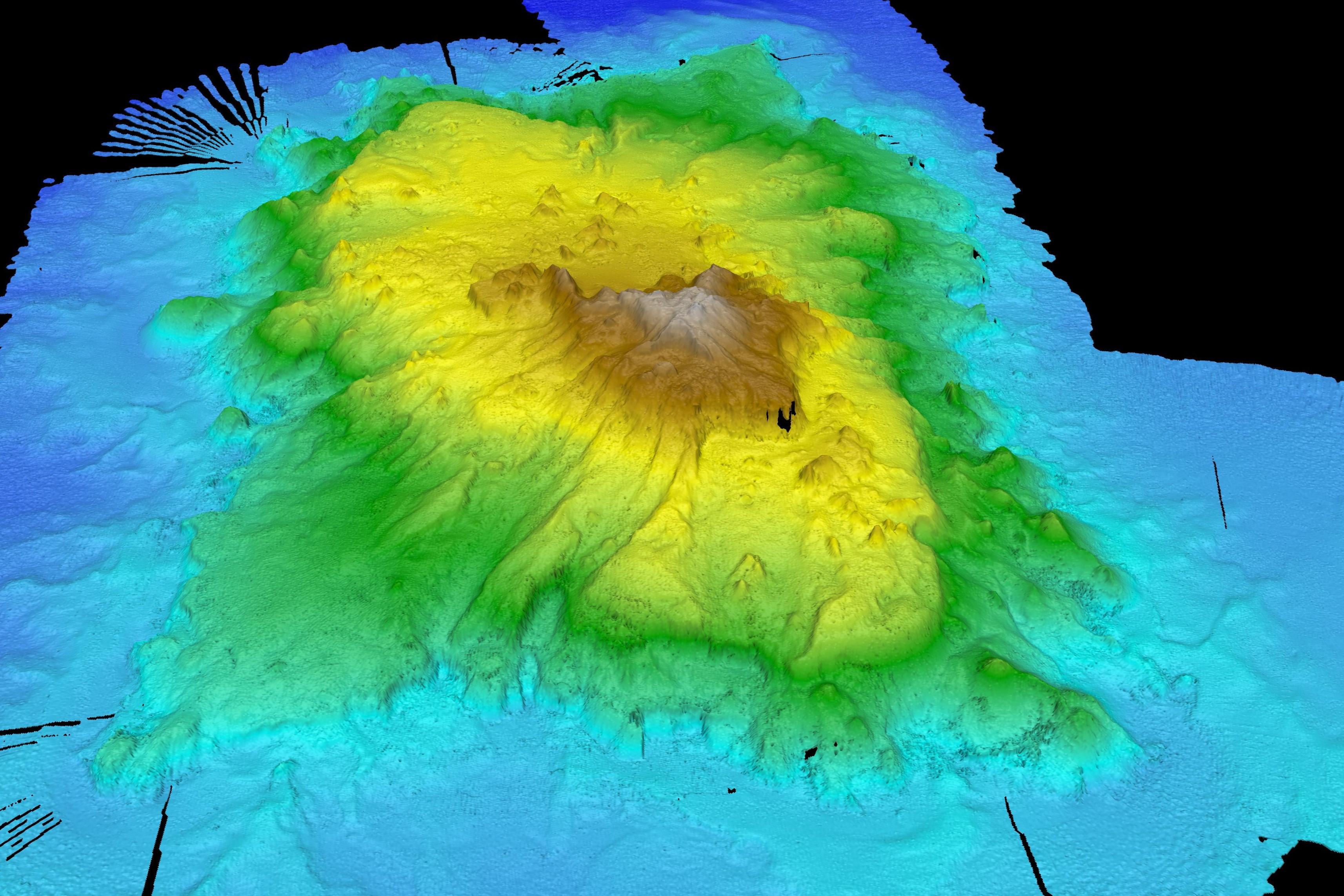
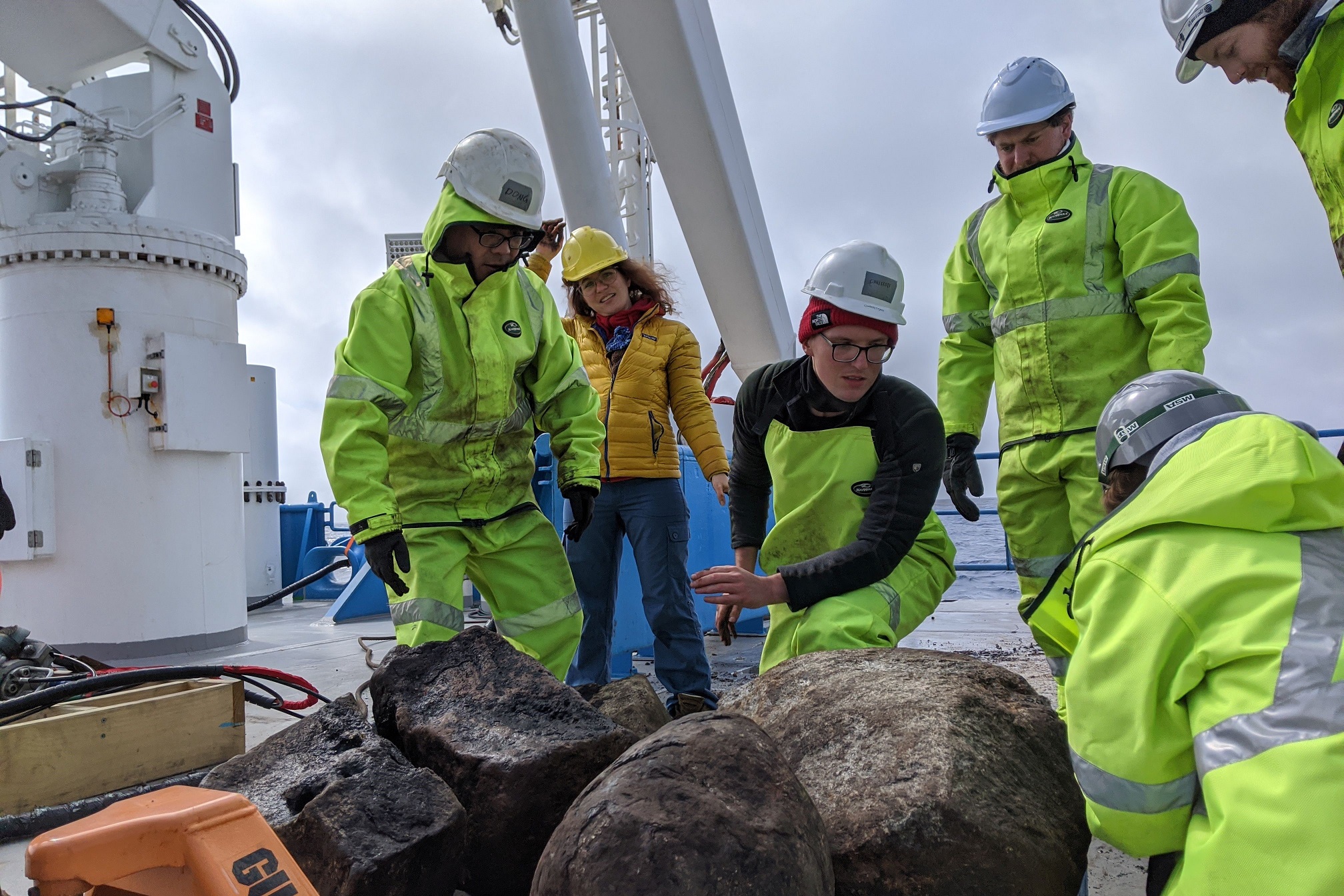
Projects in the Coral Sea off the northeast coast of Australia, examined the geology, history and origin of this region and helped to assist in management of marine parks. Researchers led projects in the Coral Sea that focused on mapping of submarine canyons and landslides along the margin of the Great Barrier Reef. Projects were also undertaken to examine the biodiversity of the Coral Sea Marine Park and to confirm the location of two WWII shipwrecks in the region (aircraft carrier USS Lexington and oil tanker USS Neosho). Also, within the Coral Sea, by analysing rocks from seamount chains and undertaking detailed mapping of the seafloor, researchers investigated how deep mantle plumes (hotspots) have influenced the evolution of the Australian plate.
In a collaborative project with Traditional Owners, mapping of the Wessels Marine Park, located off the Northern Territory coast, was undertaken which led to an extensive program of habitat mapping using multibeam sonar in this marine park, supplemented by deep-towed camera transects. The MNF also launched the Indigenous Time at Sea Scholarship (ITSS) to increase the opportunities for Aboriginal and Torres Strait Islander students to participate in the management of the marine environment.
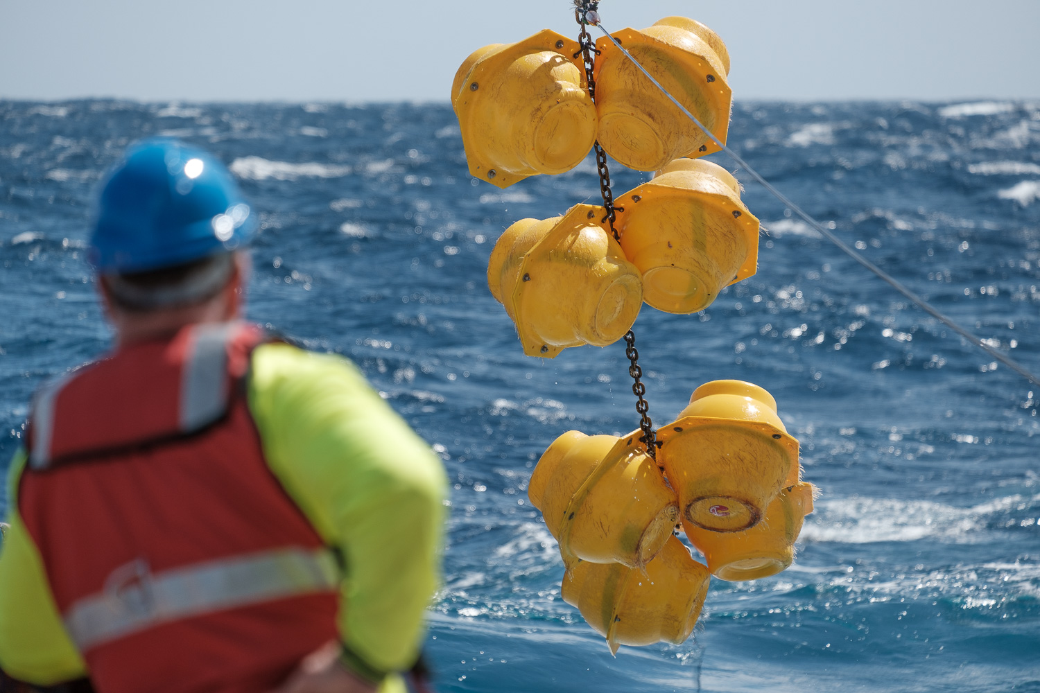
The MNF continued support for Integrated Marine Observing System (IMOS) by maintaining the East Australian Current (EAC) mooring array located off Brisbane. The data collected contributes to global datasets and increases understanding of EAC characteristics, providing information vital for informing ocean and climate modelling.
The longest voyage this year was a 60-day 10,124 nautical mile extended voyage that utilised the maximum endurance of RV Investigator. Leaving from Fremantle, the researchers travelled the Southern Ocean to collect data on the geology and geophysical environment to study the origin and development of two remote submarine plateaus. For the first time the entire length of William’s Ridge, defining both its continuity with the Central Kerguelen Plateau and its south-eastern terminus, was mapped.
The national benefits delivered by these projects included:
- understanding the planet’s geodynamic and climatic history, as well as biotic evolution
- contributing to global datasets and information on the East Australian Current vital for informing ocean and climate modelling
- increasing opportunities for Aboriginal and Torres Strait Islands students to participate in the management of the marine environment and develop their STEM experience and skillset
- improving weather and climate models in Australia’s far northern waters
- detailed 3D imagery of key landslides and canyons to increase our understanding of how and when the Great Barrier Reef formed
- increasing our understanding of the geology, geophysics, origin and development of two remote submarine plateaus
- investigating how deep mantle plumes (hotspots) have influenced the evolution of the Australian plate
- mapping historic shipwrecks for cultural heritage conservation and to assist in marine park management.
Integrated with the busy research schedule, the vessel completed a transit voyage from Fremantle to Hobart where two ocean monitoring floats were deployed as part of the Southern Ocean Carbon and Climate Observations and Modelling (SOCCOM) program. The 2019–20 year also included completion of the first five-yearly dry dock maintenance period, which was undertaken in Singapore at the same shipyard where the vessel was built.
2019–20 voyage schedule
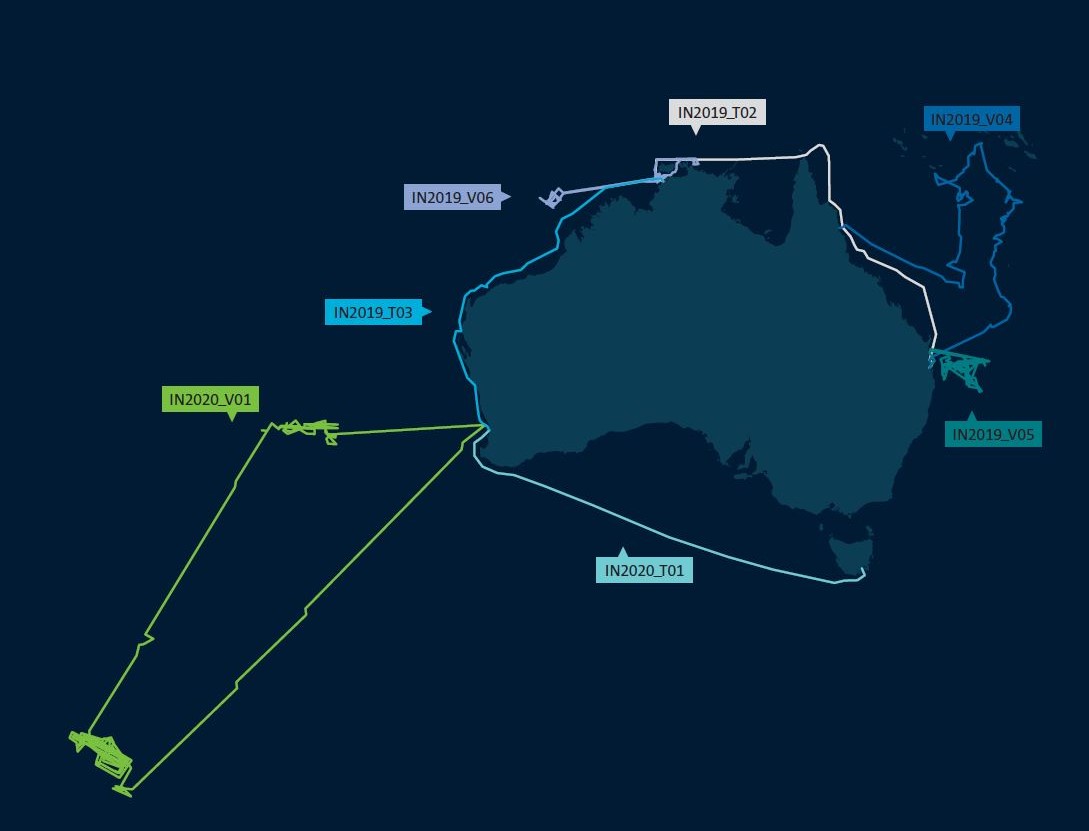
August 2019
IN2019_V04 Uncovering volcanic seascapes, marine life and shipwrecks of the Coral Sea.
Chief Scientist Associate Professor Joanne Whittaker from the University of Tasmania led research on this voyage to the Coral Sea to investigate one of the world’s most extensive volcanic regions. The research focused on how deep mantle plumes (hotspots) have influenced the evolution of the Australian plate. Scientists collected and analysed rocks from seamount chains stretching across the Coral Sea and undertook detailed mapping of the seafloor and below. Sediment and rock samples were collected from sites on the Louisiade Plateau, Tasmantid seamount chain and Lord Howe Rise seamount chain.
The voyage research has global significance for understanding Earth’s geodynamic and climatic history, increasing our comprehension of the origin of the Coral Sea region, and providing information vital to understanding the evolution of the Australian plate.
September 2019
IN2019_V05 Sustained monitoring of the East Australian Current (EAC).
Monitoring of the EAC is central to our understanding of the relationship between global ocean and climate variability. The long-term ocean monitoring by the EAC array provides important insights into the interactions between the EAC, the Pacific Basin and the local (continental) shelf ocean circulation.
MNF support for this research helps improve our understanding of the relationship of the EAC and its impact on the coastal marine ecosystem.
October 2019
IN2019_T02 Deep seascapes of the Great Barrier Reef: Uncovering submarine canyons and landslides.
Chief Scientist Dr Rob Beaman from James Cook University led a diverse range of research teams to map submarine canyons and landslides along the margin of the Great Barrier Reef (GBR). Four main areas of interest were mapped to produce 3D imagery of key landslides and canyons in the region. This research contributes to a UNESCO requirement that Australia take action to preserve the GBR as a world heritage site. This was achieved by acquiring the most recent and multidisciplinary data available. GBR data is a valuable resource for increasing understanding of a globally significant component of Australia’s marine environment.
This voyage demonstrated the wide capabilities of RV Investigator, with atmospheric, oceanographic, biological and geoscience research all being conducted, alongside education and outreach activities.
October – December 2019
IN2019_V06 Tropical observations of ocean and atmosphere to our far north.
The Bureau of Meteorology (BOM) undertook a research voyage to Australia’s far northern waters, where researchers collected unprecedented oceanic and atmospheric observations. Led by Chief Scientist, Dr Susan Wijffels of Woods Hole Oceanographic Institution, formerly of CSIRO, on the first leg of the voyage, existing models simulating the process of convection over Darwin and surrounds were confirmed to be accurate. However, in the second leg, led by Chief Scientist Dr Alain Protat from BOM, the extensive hydrographic, atmospheric and physical readings collected showed unexpected growth and propagation of offshore weather-related processes.
Results from the voyage provide the fundamental scientific knowledge upon which BOM weather forecasting and climate models will be improved to better simulate tropical convection and ocean–atmosphere coupling. This will aid both daily forecast outlets as well as improve the ability to detect storm propagation hundreds of kilometres offshore.
Several isolated unialgal cultures and live phytoplankton specimens were also collected during the voyage. These will be studied to assess their impacts on regional biogenic emissions. The specimens will be kept in a living ‘biobank’ so that they can be used in future oceanographic studies. Many additional biological samples were collected for ongoing metagenomics investigations.
MNF’s support for these outcomes delivers into national priorities to conserve our biodiversity and ecosystem health.
December 2019 – January 2020
IN2019_T03 Calibrating Australia’s operational radar network.
During the transit voyage from Darwin to Fremantle, several research, education and outreach projects were undertaken. The Chief Scientist, Dr Alain Protat from BOM, led a project to use RV Investigator’s advanced weather radar as a moving reference point for BOM operational radar network located along Australia’s west coast. The data collected was used to calibrate this sector of Australia’s operational radar network.
The science team on this voyage included 27 participants from eight institutions and included two Australian schoolteachers under the CSIRO Educator on Board Program and the first two university students under the MNF Indigenous Time at Sea Scholarship.
This was the first time that the vessel had been at sea over Christmas.
January – March 2020
IN2020_V01 Mapping to inform Australia’s marine jurisdiction.
On this extended voyage to the Southern Ocean over 60 days and 10,000 nautical miles, the origin and development of two remote submarine plateaus were studied in the south-east Indian Ocean. Led by Chief Scientist Professor Mike Coffin from the Institute for Marine and Antarctic Studies (IMAS), 38 participants from 14 institutions collected geology and geophysics data on the Kerguelen Plateau and Broken Ridge to increase understanding of how these plateaus, once joined together, rifted and broke apart.
The outcomes of this research will contribute towards Australia maintaining, and building, a secure and prosperous maritime territory.
March – June 2020
IN2020_T01 At-sea operations suspended due to COVID-19 pandemic.
While at-sea operations were suspended, scientists made the most of having RV Investigator in port by using the ship’s instruments to collect valuable data about Hobart’s air quality. The data collected will offer a unique snapshot of Hobart air quality during the COVID-19 shutdown and provide an opportunity to compare this with other years. The data collected will be used in several national and international monitoring programs, including a new urban air quality study being led by the Queensland University of Technology (QUT).
The time in port was also used to conduct various equipment maintenance and system upgrades, providing an opportunity for the ongoing development and improvement of ship capability.
Voyage spotlight
Epic ocean voyage to extend Australia’s maritime territory
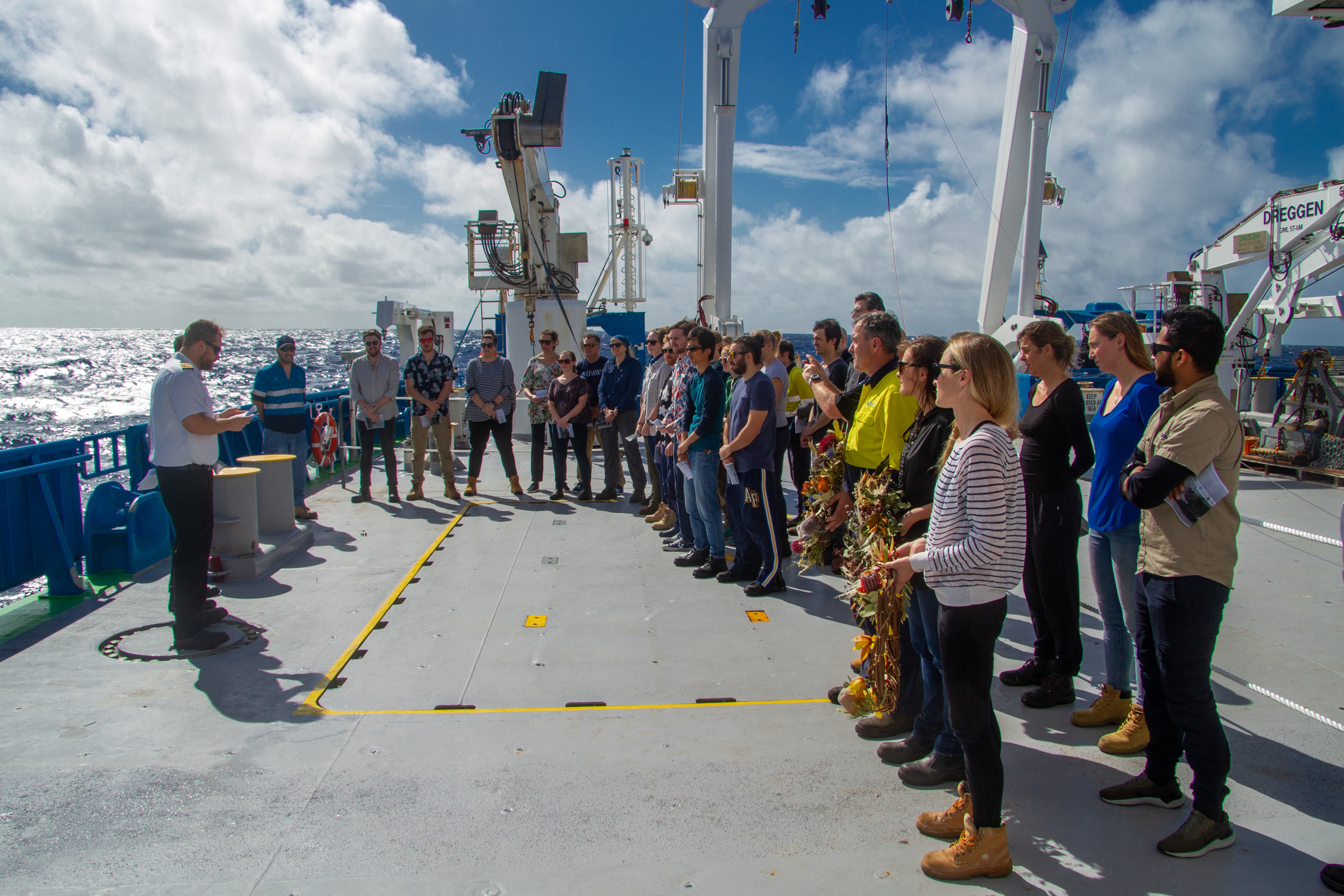
In January 2020, RV Investigator departed Perth for a two-month voyage to push the boundaries of both vessel endurance and Australia’s marine jurisdiction. On board was an international science team of 57 including researchers from 13 institutions and 11 countries: Australia, Canada, China, Denmark, Germany, Italy, Poland, Singapore, Turkey, UK and USA.
Led by Professor Mike Coffin from the Institute for Marine and Antarctic Studies (IMAS), the main objective of the voyage was to acquire data and samples to establish whether a region of seafloor the size of Switzerland qualifies to be included in Australia’s marine territory.
By voyage end, the team had mapped more than 100,000 km2 of seafloor, much of it for the first time, and set new endurance records for both vessel distance travelled (10,124 nautical miles) and days at sea (57 days).
The voyage set out to increase our understanding of the ancient rifting, break-up and separation of tectonic plates in the Indian Ocean that split a giant oceanic plateau into two major seafloor features: Broken Ridge and the Kerguelen Plateau. These features are now over 2,700 kilometres apart after separating around 43 million years ago.
Previously, the geological origin of William’s Ridge, a seafloor feature adjacent to the Kerguelen Plateau (which includes Australia’s Territory of Heard Island and McDonald Islands), was considered unresolved and it had not been included as part of Australia’s marine territory.
The entire length of William’s Ridge was mapped, defining both its continuity with the Kerguelen Plateau and its south-eastern limit for the first time. This information, along with results from post-voyage analyses of the rock samples that were collected, will be used to address criteria for a future submission to the United Nations Commission on the Limits of the Continental Shelf.
If judged eligible, it could add 40,000 square kilometres to the continental shelf recognised as part of Australia’s marine territory.
Communication and engagement
The MNF is dedicated to informing the citizens, government and industry of Australia of the research, education and training we deliver to demonstrate return on investment and share the remarkable stories that come from the vessel’s voyages.
The MNF collaborates widely with the marine research community to support the regular delivery of communications, education programs and engagement events that are relevant, engaging and easily accessible.
The 2019–20 year saw the launch of a redesigned MNF website (mnf.csiro.au). The new website offers a much more user friendly and engaging format, with increased multimedia content, voyage specific information, and higher levels of functionality for ship users and other stakeholders.
Communication spotlight
A landmark documentary featuring RV Investigator
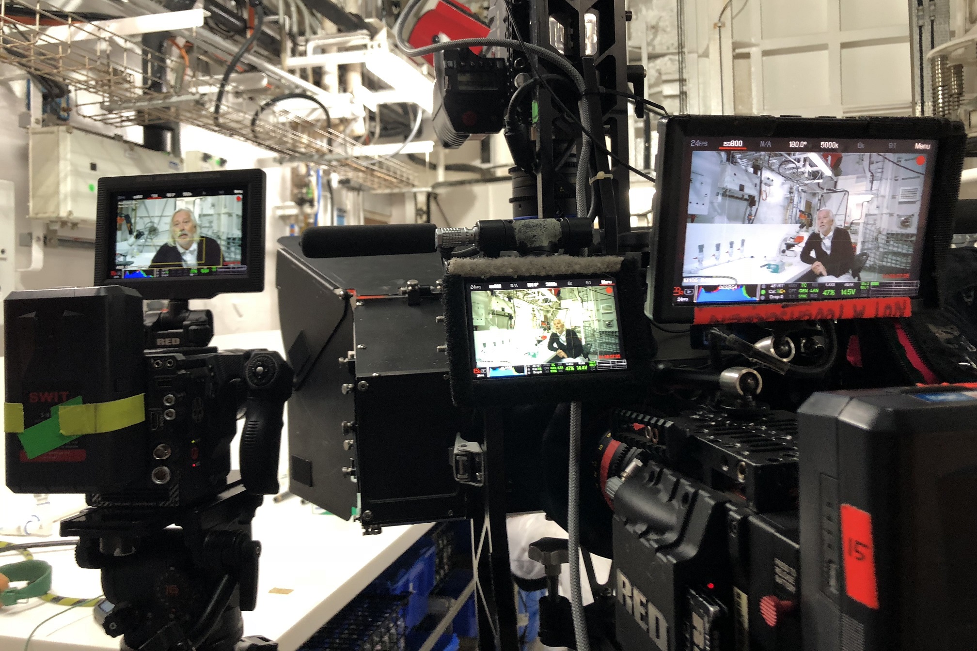
In June 2020, ABC aired the acclaimed documentary series Australia’s Ocean Odyssey. This three-part series told the story of the East Australian Current (EAC), revealing how it shapes life both on land and in sea. The series featured a 2018 voyage of RV Investigator, showcasing to a national audience of more than 1.5 million viewers the role of CSIRO in delivering excellent marine research. Widely promoted by the ABC and participating institutions, the series had a strong focus on science messaging, and highlighted the important impact of the research featured.
Our involvement in the series not only promoted our work but also allowed CSIRO to present media opportunities to research partners, both during filming and broadcast of the series.
Collaboration is central to the MNF communications strategy. Providing direct access and sharing the vessel’s impressive communication capabilities with media and our research partners – through both real and virtual access – directly contributes to our objective of making the research we deliver accessible to the public. It also fosters a unique environment for collaborative marine science communications. In addition to the documentary team, this voyage also included an ABC journalist, who worked with those on board to file multiple stories about the voyage, including delivering live TV broadcasts from sea.
Working with media to tell the story of our work is important. Media play a crucial role in not only raising our profile, but also in shaping public attitudes about the marine environment. Our participation in programs such as Australia’s Ocean Odyssey makes an important contribution towards raising scientific literacy within the community. Increasingly, for many people, their understanding of science comes from what they are exposed to in the media.
These activities highlight to the Australian community why the research we deliver is important and how it benefits the nation.
Improving our capabilities
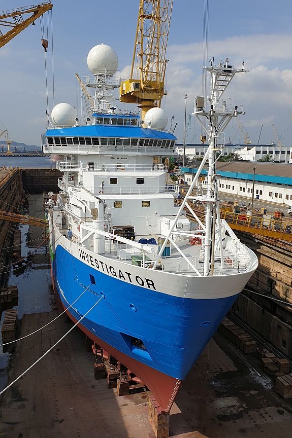
In July 2019, RV Investigator completed its first mandatory five-year dry docking to renew class certificates and undergo scheduled maintenance.
The dry docking was completed in the Sembawang Shipyard in Singapore where RV Investigator was built. While in dry dock maintenance was completed on underway scientific instruments located in the gondola beneath the ship’s hull, upgrades commenced on the Vertical Sediment Winch (VSW) and Core Handling System (CHS) and the ship received a fresh coat of paint.
Following dry docking, RV Investigator successfully completed sea trials and system calibrations on the return voyage to Australia. This included commissioning of the newly acquired 2D Seismic Data Acquisition System (SDAS), funded by Geoscience Australia, which was then successfully used during the Southern Ocean voyage in January 2020.
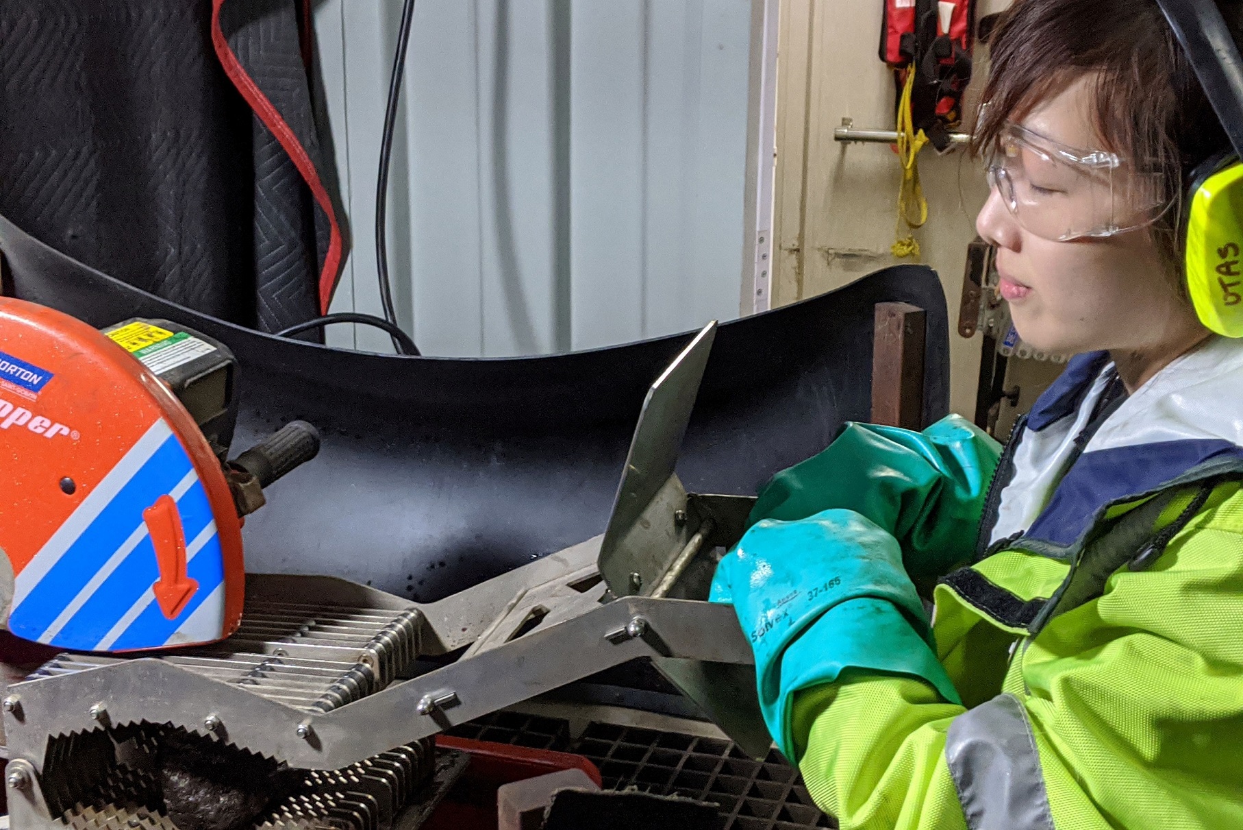
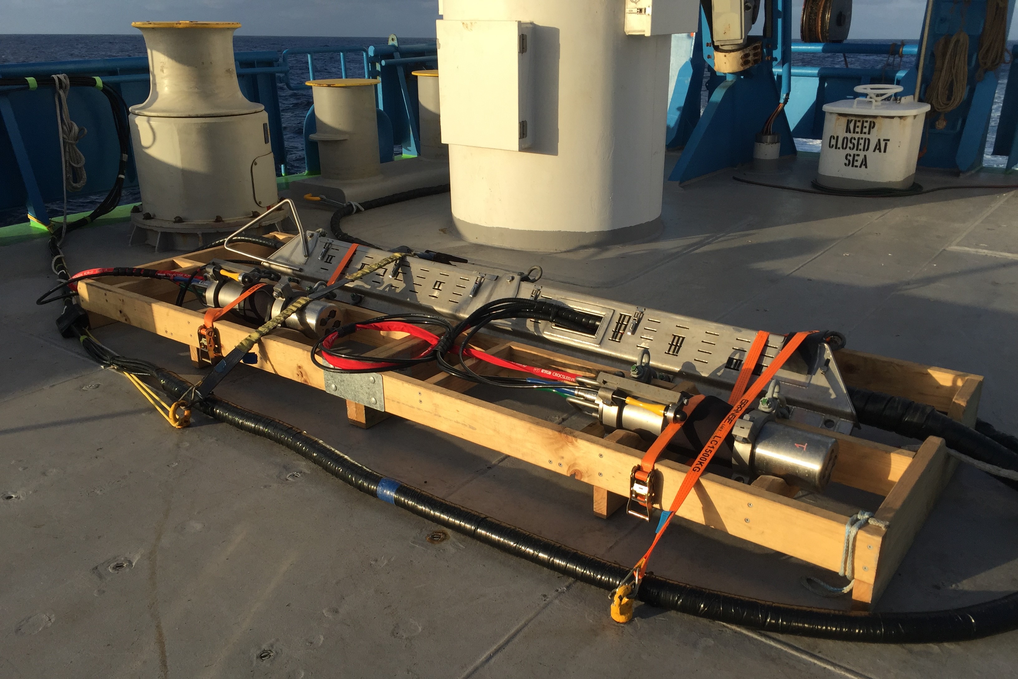
Capability enhancements completed under the MNF Capital Procurement Plan for 2019–2020 included the Hydrobias Net System, upgraded Deep Towed Camera, OSIL giant piston corer, and radioisotope containerised laboratory refit. Procurement also commenced for the Heavy Ocean Towing System (HOTS) project. This significant capability enhancement will allow fully instrumented deployments (via fibre optic cable) of heavy towed equipment down to 6500 m. Currently, achievable depths on the existing steel wire are 3000 m. The project will be the first of its kind to use a fibre optic steel coated wire on a direct drive winch. It is partly funded through the Science Innovation Endowment Fund (SIEF) and is scheduled for completion in September 2021.
The COVID-19 pandemic impacted on capability enhancement projects during 2019–20, primarily as a result of travel restrictions limiting access to key personnel needed to complete and commission projects. The MNF is looking at new ways of completing commissioning activities in future without the need for physical attendance by the manufacturers.
Financial statement
Strong financial management is critical to ensuring the MNF remains viable, effective, and accountable for the expenditure of public funds.
| 2018-19 | 2019-20 | ||
|---|---|---|---|
| $'000 | $'000 | ||
| Revenue | |||
| External Funding | 4,472 | 7,745 | |
| Internal Funding | 26,214 | 26,567 | |
| Total Revenue | 30,686 | 34,312 | |
| Expenditure | |||
| Labour | 8,378 | 9,000 | |
| Other operating | 19,614 | 23,684 | |
| Total Expenditure | 27,993 | 32,683 | |
| Operating Result* | 2,693 | 1,629 | |
| Capital | |||
| Capital expenditure* | 4,028 | 2,314 | |
* 2019–20 includes $1.571 million of externally funded capital expenditure.
2018–19 includes $2.926 million of externally funded capital expenditure.
Looking to the future – MNF 2030
In 2019, a review was undertaken of the MNF access framework to explore options on how to strengthen the alignment and use of the MNF with national priorities for marine and atmospheric research. In response to the recommendations from this review, the MNF 2030 strategy was produced.
This ambitious 10-year strategy will guide the use of Australia’s dedicated blue-water research capabilities. The strategy introduces improvements in the way researchers can access sea-time on RV Investigator and in annual scheduling of activities. The strategy also reinforces the MNF commitment to operational excellence, capability development, and STEM education and training.
Based on experience operating RV Investigator since commissioning in 2014, the MNF believes that by taking a more active role in managing our science capabilities, increased public benefit and broader access will be delivered.
The MNF 2030 strategy introduces six new pillars which reflect a shift in approach.
- Maximum impact: Introducing MNF policy-driven priorities, set and regularly reviewed in consultation with government, the research community and relevant industry stakeholders, to encourage and support high-impact projects.
- Broad access: Defining five categories (access Streams) for sea-time applications to better reflect the breadth of needs and demands of the Australian research community and encourage new users.
- Streamlined operations and optimal use: Introducing a more flexible scheduling approach and streamlined digital tools for applicants and researchers coming on board to improve operational efficiencies and reduce administrative burden.
- Advanced capabilities and innovation: To guide capital expenditure and balance short-term operational responsiveness with strategic enhancement of research capabilities.
- Training future generations: Enhancing the MNF education and training program to include training the next generation of marine researchers and technicians in collaboration with other research/operational agencies and industries.
- Connecting with Australians and the world: Deepen Australians understanding of ocean research and of the MNF value and contribution to solving key challenges by increasing focus on communicating the impact of research delivered by the MNF.
MNF 2030 maps out an ambitious course for the MNF over the next decade. The strategic objectives and key actions under each pillar are intended to keep us on course to fulfil our mission to facilitate safe, efficient and excellent marine and atmospheric research that is aligned with national priorities and addresses challenges facing Australia’s society, economy and environment.
For further information
Marine National Facility
t +61 3 6232 5222
e mnf@csiro.au
w mnf.csiro.au
The Marine National Facility is owned and operated by CSIRO on behalf of the nation.
Download the Annual Report 2019-20:
Marine National Facility
Annual Report 2019-20
Australia's world-class marine research capability
Australia has jurisdiction over the third largest marine estate in the world and our ocean territory contains a wide diversity of habitats. The Marine National Facility (MNF) provides a blue-water research capability to the Australian research community and their international collaborators to study this immense and diverse area.
The MNF is funded by the Australian Government and owned and operated by CSIRO on behalf of the nation. It includes the multidisciplinary Research Vessel (RV) Investigator, a suite of scientific equipment, technical staff and expertise, and more than 35 years of freely available marine data.
RV Investigator can accommodate a science team of 40 participants and can be at sea for up to 60 days and cover 10,000 nautical miles per voyage, operating anywhere from the Antarctic ice edge to the tropics. RV Investigator has been purpose built to meet the needs of Australian marine researchers as a highly capable platform for multidisciplinary research, including geology and geophysics, biology, biogeochemistry, climate and meteorology.
The research conducted on MNF voyages provides important information that supports evidence-based decision-making by government, industry and other stakeholders. Our goal is to enhance the long-term viability and prosperity of the Australian marine environment, industries and community. In doing so we strive to facilitate safe, efficient and excellent marine and atmospheric research that addresses the challenges that Australia faces, now and into the future.
From the Chairperson
There has never been a more important time to have a solid strategy combined with an eye on the future to help navigate the impacts of a worldwide pandemic on the operations of the Marine National Facility (MNF). In 2019–20, the MNF was scheduled to deliver 303 days of merit‑based research. The impact of the COVID-19 pandemic, however, led to the MNF taking proactive health and safety measures and imposing restrictions on operations. Most significantly, travel restrictions caused significant disruption for a facility that provides an international hub for collaboration in research.
Alongside the halt of operations caused by the pandemic, the 2019–20 year saw the development of the MNF 2030 strategy, which maps out an ambitious course for the MNF over the next decade. The strategy describes the directions the MNF will take in the pursuit of operational excellence, capability improvements, and education and outreach opportunities. The strategy also introduces improvements in the way researchers can access time on RV Investigator and in annual scheduling of activities.
The Australian Government, through the CSIRO and the National Collaborative Research Infrastructure Strategy, funds the MNF to operate RV Investigator to deliver a full-year research program. The strategic objectives and key actions outlined in the new strategy are intended to keep us on course to fulfil our mission to facilitate safe, efficient and excellent marine and atmospheric research that has national benefit and actively promotes clear alignment with government and industry priorities.
In looking to the future and based on the experience of the MNF team, I believe that increased public benefit and broader access will be delivered by taking a more active role in managing science capabilities through the new strategy.
This annual report tells many stories of the value we are delivering to our partners and across industry, government and the research community, as well as to every Australian. The RV Investigator continued to prove it is a highly capable, multi-purpose, dedicated research platform that enables researchers to address Australia’s most pressing challenges. This is achieved in some of the most remote and wild reaches of the global ocean. The impact of COVID-19 has not lessened the impact of the research that continues to be conducted by the MNF, to benefit Australia and the world.
Everything the MNF does is driven by our extraordinary and committed team members. I want to thank the whole MNF team for their commitment and dedication during the unexpected events of this year.
Dr Sue Barrell
Chairperson, MNF Steering Committee
From the Director
It was only last year that the Marine National Facility (MNF) started full year operations and the 2019–20 year was set to deliver approximately 300 days at sea. Though the MNF chose to suspend operations for a period as a result of the impact of the pandemic, the MNF team has performed remarkably well given the hardships COVID-19 has brought with it.
I look back on all that the MNF has achieved this year, given the extraordinary circumstances facing its operations, and believe our people have shown what a critical part they play in ensuring Australia’s future sustainability, prosperity and security. Over 2019–20, members of the MNF worked strategically and closely with those affected by the hold on operations to identify options for rescheduling of research projects and in planning to accommodate competing demands of both research and maintenance.
The MNF was still able to deliver a wide range of research in 2019–20 and, though originally scheduling seven research voyages to take place, the impact of COVID-19 and the proactive health and safety measures employed by the MNF meant there were less than planned. Even with the significant challenges faced, the MNF was able to successfully deliver four research voyages, one sea trial and three transit voyages, as well as delivering the first of the mandatory 5-year dry docks for the vessel.
RV Investigator this year hosted researchers who studied the origin and development of two remote submarine plateaus in the Southern Ocean. The data collected from this voyage will inform a submission to the United Nations that may lead to Australia’s marine jurisdiction being extended by an area the size of Switzerland. This research helps Australia maintain a secure and prosperous maritime territory.
During 2019–20, the MNF exhibited our ongoing commitment to educating and training Australia’s next generation of marine researchers, including supporting participation in research by Aboriginal and Torres Strait Islander peoples. The MNF launched the Indigenous Time at Sea Scholarship to increase opportunities for Aboriginal and Torres Strait Islands university students to participate in the management of the marine environment and develop the STEM skills critical for Australia’s future workforce. The benefits of the experience and mentoring received by students during voyages is long lasting and a critical investment for Australia’s future marine industries.
The voyages that took place in 2019–20 exemplify the multi-disciplinary research that RV Investigator makes possible. From gathering data by the mapping of submarine canyons and landslides along the margin of the Great Barrier Reef, uncovering the location of WWII shipwrecks and investigation into deep mantle plumes that influenced the evolution of the Australian plate, 2019–20 was a productive year.
I would like to extend my heartfelt thanks to the staff in the MNF team, the Engineering and Technology Team that supports the technical operations, and the Crew from ASP Ship Management for their work and flexibility that made it possible for the ship to return to sea safely this year.
Toni Moate
Director, Marine National Facility
2019-20 snapshot
COVID-19 implications and measures
The 2019–20 period presented a particularly challenging landscape for the delivery of at-sea research with the global COVID-19 pandemic having a significant impact on MNF operations. Paramount in decision making about MNF operations is the health and wellbeing of our people, partners and the community so, based on available medical advice and assessment of the situation, the MNF acted decisively in early 2020 and took proactive measures to safeguard health and prevent spread of COVID-19.
The MNF was initially scheduled for continuation of full‑year operations and the delivery of 303 research days in the planned voyage schedule. The impact of the COVID-19 pandemic, including travel restrictions affecting movement of people and cargo, necessitated that the MNF cancel voyages and reschedule research projects.
At-sea operations of RV Investigator were suspended during March 2020 and the ship returned to its home port of Hobart, Tasmania. At-sea operations did not resume during 2019–20. The suspension of operations resulted in one voyage being cancelled, and five others being rescheduled. These disruptions led to numerous other flow-on impacts to the future research schedule.
The MNF worked closely with those affected by this unavoidable disruption to the voyage schedule in order to identify options for rescheduling of research projects, as well as manage the competing demands of research and vessel maintenance. The disruption also impacted on the planned education, training and outreach programs of the MNF, with the cancellation of numerous activities and events.
In response to the COVID-19 pandemic and its impact, the MNF commenced development of a framework to safely and efficiently manage operations under a set of modified operating protocols. These protocols were designed to safeguard the safety and wellbeing of those on board while enabling the successful resumption of at-sea operations in a global environment where COVID-19 persisted. While the situation remained unpredictable at the conclusion of the period, the response framework and planning are well underway to enable a safe and effective restart of at-sea operations early in the new financial year.
The MNF Steering Committee endorses a voyage schedule for each financial year that allocates approximately 300 days of project time on RV Investigator to research proposals that are deemed meritorious in the application process. Historically, the MNF has achieved or exceeded targets set for allocation of sea time. In 2019–20 and in spite of significant disruptions to operations, the MNF was still able to successfully deliver 70 per cent of the allocated 303 research days, with only 92 of planned research days not being delivered due to the impact of the COVID-19 pandemic.
Research delivered and supported
The MNF delivered a wide range of research in 2019–20.
Projects in the Coral Sea off the northeast coast of Australia, examined the geology, history and origin of this region and helped to assist in management of marine parks. Researchers led projects in the Coral Sea that focused on mapping of submarine canyons and landslides along the margin of the Great Barrier Reef. Projects were also undertaken to examine the biodiversity of the Coral Sea Marine Park and to confirm the location of two WWII shipwrecks in the region (aircraft carrier USS Lexington and oil tanker USS Neosho). Also, within the Coral Sea, by analysing rocks from seamount chains and undertaking detailed mapping of the seafloor, researchers investigated how deep mantle plumes (hotspots) have influenced the evolution of the Australian plate.
In a collaborative project with Traditional Owners, mapping of the Wessels Marine Park, located off the Northern Territory coast, was undertaken which led to an extensive program of habitat mapping using multibeam sonar in this marine park, supplemented by deep-towed camera transects. The MNF also launched the Indigenous Time at Sea Scholarship (ITSS) to increase the opportunities for Aboriginal and Torres Strait Islander students to participate in the management of the marine environment.
The MNF continued support for Integrated Marine Observing System (IMOS) by maintaining the East Australian Current (EAC) mooring array located off Brisbane. The data collected contributes to global datasets and increases understanding of EAC characteristics, providing information vital for informing ocean and climate modelling.
The longest voyage this year was a 60-day 10,124 nautical mile extended voyage that utilised the maximum endurance of RV Investigator. Leaving from Fremantle, the researchers travelled the Southern Ocean to collect data on the geology and geophysical environment to study the origin and development of two remote submarine plateaus. For the first time the entire length of William’s Ridge, defining both its continuity with the Central Kerguelen Plateau and its south-eastern terminus, was mapped.
The national benefits delivered by these projects included:
- understanding the planet’s geodynamic and climatic history, as well as biotic evolution
- contributing to global datasets and information on the East Australian Current vital for informing ocean and climate modelling
- increasing opportunities for Aboriginal and Torres Strait Islands students to participate in the management of the marine environment and develop their STEM experience and skillset
- improving weather and climate models in Australia’s far northern waters
- detailed 3D imagery of key landslides and canyons to increase our understanding of how and when the Great Barrier Reef formed
- increasing our understanding of the geology, geophysics, origin and development of two remote submarine plateaus
- investigating how deep mantle plumes (hotspots) have influenced the evolution of the Australian plate
- mapping historic shipwrecks for cultural heritage conservation and to assist in marine park management.
Integrated with the busy research schedule, the vessel completed a transit voyage from Fremantle to Hobart where two ocean monitoring floats were deployed as part of the Southern Ocean Carbon and Climate Observations and Modelling (SOCCOM) program. The 2019–20 year also included completion of the first five-yearly dry dock maintenance period, which was undertaken in Singapore at the same shipyard where the vessel was built.
2019–20 voyage schedule
August 2019
IN2019_V04 Uncovering volcanic seascapes, marine life and shipwrecks of the Coral Sea.
Chief Scientist Associate Professor Joanne Whittaker from the University of Tasmania led research on this voyage to the Coral Sea to investigate one of the world’s most extensive volcanic regions. The research focused on how deep mantle plumes (hotspots) have influenced the evolution of the Australian plate. Scientists collected and analysed rocks from seamount chains stretching across the Coral Sea and undertook detailed mapping of the seafloor and below. Sediment and rock samples were collected from sites on the Louisiade Plateau, Tasmantid seamount chain and Lord Howe Rise seamount chain.
The voyage research has global significance for understanding Earth’s geodynamic and climatic history, increasing our comprehension of the origin of the Coral Sea region, and providing information vital to understanding the evolution of the Australian plate.
September 2019
IN2019_V05 Sustained monitoring of the East Australian Current (EAC).
Monitoring of the EAC is central to our understanding of the relationship between global ocean and climate variability. The long-term ocean monitoring by the EAC array provides important insights into the interactions between the EAC, the Pacific Basin and the local (continental) shelf ocean circulation.
MNF support for this research helps improve our understanding of the relationship of the EAC and its impact on the coastal marine ecosystem.
October 2019
IN2019_T02 Deep seascapes of the Great Barrier Reef: Uncovering submarine canyons and landslides.
Chief Scientist Dr Rob Beaman from James Cook University led a diverse range of research teams to map submarine canyons and landslides along the margin of the Great Barrier Reef (GBR). Four main areas of interest were mapped to produce 3D imagery of key landslides and canyons in the region. This research contributes to a UNESCO requirement that Australia take action to preserve the GBR as a world heritage site. This was achieved by acquiring the most recent and multidisciplinary data available. GBR data is a valuable resource for increasing understanding of a globally significant component of Australia’s marine environment.
This voyage demonstrated the wide capabilities of RV Investigator, with atmospheric, oceanographic, biological and geoscience research all being conducted, alongside education and outreach activities.
October – December 2019
IN2019_V06 Tropical observations of ocean and atmosphere to our far north.
The Bureau of Meteorology (BOM) undertook a research voyage to Australia’s far northern waters, where researchers collected unprecedented oceanic and atmospheric observations. Led by Chief Scientist, Dr Susan Wijffels of Woods Hole Oceanographic Institution, formerly of CSIRO, on the first leg of the voyage, existing models simulating the process of convection over Darwin and surrounds were confirmed to be accurate. However, in the second leg, led by Chief Scientist Dr Alain Protat from BOM, the extensive hydrographic, atmospheric and physical readings collected showed unexpected growth and propagation of offshore weather-related processes.
Results from the voyage provide the fundamental scientific knowledge upon which BOM weather forecasting and climate models will be improved to better simulate tropical convection and ocean–atmosphere coupling. This will aid both daily forecast outlets as well as improve the ability to detect storm propagation hundreds of kilometres offshore.
Several isolated unialgal cultures and live phytoplankton specimens were also collected during the voyage. These will be studied to assess their impacts on regional biogenic emissions. The specimens will be kept in a living ‘biobank’ so that they can be used in future oceanographic studies. Many additional biological samples were collected for ongoing metagenomics investigations.
MNF’s support for these outcomes delivers into national priorities to conserve our biodiversity and ecosystem health.
December 2019 – January 2020
IN2019_T03 Calibrating Australia’s operational radar network.
During the transit voyage from Darwin to Fremantle, several research, education and outreach projects were undertaken. The Chief Scientist, Dr Alain Protat from BOM, led a project to use RV Investigator’s advanced weather radar as a moving reference point for BOM operational radar network located along Australia’s west coast. The data collected was used to calibrate this sector of Australia’s operational radar network.
The science team on this voyage included 27 participants from eight institutions and included two Australian schoolteachers under the CSIRO Educator on Board Program and the first two university students under the MNF Indigenous Time at Sea Scholarship.
This was the first time that the vessel had been at sea over Christmas.
January – March 2020
IN2020_V01 Mapping to inform Australia’s marine jurisdiction.
On this extended voyage to the Southern Ocean over 60 days and 10,000 nautical miles, the origin and development of two remote submarine plateaus were studied in the south-east Indian Ocean. Led by Chief Scientist Professor Mike Coffin from the Institute for Marine and Antarctic Studies (IMAS), 38 participants from 14 institutions collected geology and geophysics data on the Kerguelen Plateau and Broken Ridge to increase understanding of how these plateaus, once joined together, rifted and broke apart.
The outcomes of this research will contribute towards Australia maintaining, and building, a secure and prosperous maritime territory.
March – June 2020
IN2020_T01 At-sea operations suspended due to COVID-19 pandemic.
While at-sea operations were suspended, scientists made the most of having RV Investigator in port by using the ship’s instruments to collect valuable data about Hobart’s air quality. The data collected will offer a unique snapshot of Hobart air quality during the COVID-19 shutdown and provide an opportunity to compare this with other years. The data collected will be used in several national and international monitoring programs, including a new urban air quality study being led by the Queensland University of Technology (QUT).
The time in port was also used to conduct various equipment maintenance and system upgrades, providing an opportunity for the ongoing development and improvement of ship capability.
Voyage spotlight
Epic ocean voyage to extend Australia’s maritime territory
In January 2020, RV Investigator departed Perth for a two-month voyage to push the boundaries of both vessel endurance and Australia’s marine jurisdiction. On board was an international science team of 57 including researchers from 13 institutions and 11 countries: Australia, Canada, China, Denmark, Germany, Italy, Poland, Singapore, Turkey, UK and USA.
Led by Professor Mike Coffin from the Institute for Marine and Antarctic Studies (IMAS), the main objective of the voyage was to acquire data and samples to establish whether a region of seafloor the size of Switzerland qualifies to be included in Australia’s marine territory.
By voyage end, the team had mapped more than 100,000 km2 of seafloor, much of it for the first time, and set new endurance records for both vessel distance travelled (10,124 nautical miles) and days at sea (57 days).
The voyage set out to increase our understanding of the ancient rifting, break-up and separation of tectonic plates in the Indian Ocean that split a giant oceanic plateau into two major seafloor features: Broken Ridge and the Kerguelen Plateau. These features are now over 2,700 kilometres apart after separating around 43 million years ago.
Previously, the geological origin of William’s Ridge, a seafloor feature adjacent to the Kerguelen Plateau (which includes Australia’s Territory of Heard Island and McDonald Islands), was considered unresolved and it had not been included as part of Australia’s marine territory.
The entire length of William’s Ridge was mapped, defining both its continuity with the Kerguelen Plateau and its south-eastern limit for the first time. This information, along with results from post-voyage analyses of the rock samples that were collected, will be used to address criteria for a future submission to the United Nations Commission on the Limits of the Continental Shelf.
If judged eligible, it could add 40,000 square kilometres to the continental shelf recognised as part of Australia’s marine territory.
Communication and engagement
The MNF is dedicated to informing the citizens, government and industry of Australia of the research, education and training we deliver to demonstrate return on investment and share the remarkable stories that come from the vessel’s voyages.
The MNF collaborates widely with the marine research community to support the regular delivery of communications, education programs and engagement events that are relevant, engaging and easily accessible.
The 2019–20 year saw the launch of a redesigned MNF website (mnf.csiro.au). The new website offers a much more user friendly and engaging format, with increased multimedia content, voyage specific information, and higher levels of functionality for ship users and other stakeholders.
Communication spotlight
A landmark documentary featuring RV Investigator
In June 2020, ABC aired the acclaimed documentary series Australia’s Ocean Odyssey. This three-part series told the story of the East Australian Current (EAC), revealing how it shapes life both on land and in sea. The series featured a 2018 voyage of RV Investigator, showcasing to a national audience of more than 1.5 million viewers the role of CSIRO in delivering excellent marine research. Widely promoted by the ABC and participating institutions, the series had a strong focus on science messaging, and highlighted the important impact of the research featured.
Our involvement in the series not only promoted our work but also allowed CSIRO to present media opportunities to research partners, both during filming and broadcast of the series.
Collaboration is central to the MNF communications strategy. Providing direct access and sharing the vessel’s impressive communication capabilities with media and our research partners – through both real and virtual access – directly contributes to our objective of making the research we deliver accessible to the public. It also fosters a unique environment for collaborative marine science communications. In addition to the documentary team, this voyage also included an ABC journalist, who worked with those on board to file multiple stories about the voyage, including delivering live TV broadcasts from sea.
Working with media to tell the story of our work is important. Media play a crucial role in not only raising our profile, but also in shaping public attitudes about the marine environment. Our participation in programs such as Australia’s Ocean Odyssey makes an important contribution towards raising scientific literacy within the community. Increasingly, for many people, their understanding of science comes from what they are exposed to in the media.
These activities highlight to the Australian community why the research we deliver is important and how it benefits the nation.
Improving our capabilities
In July 2019, RV Investigator completed its first mandatory five-year dry docking to renew class certificates and undergo scheduled maintenance.
The dry docking was completed in the Sembawang Shipyard in Singapore where RV Investigator was built. While in dry dock maintenance was completed on underway scientific instruments located in the gondola beneath the ship’s hull, upgrades commenced on the Vertical Sediment Winch (VSW) and Core Handling System (CHS) and the ship received a fresh coat of paint.
Following dry docking, RV Investigator successfully completed sea trials and system calibrations on the return voyage to Australia. This included commissioning of the newly acquired 2D Seismic Data Acquisition System (SDAS), funded by Geoscience Australia, which was then successfully used during the Southern Ocean voyage in January 2020.
Capability enhancements completed under the MNF Capital Procurement Plan for 2019–2020 included the Hydrobias Net System, upgraded Deep Towed Camera, OSIL giant piston corer, and radioisotope containerised laboratory refit. Procurement also commenced for the Heavy Ocean Towing System (HOTS) project. This significant capability enhancement will allow fully instrumented deployments (via fibre optic cable) of heavy towed equipment down to 6500 m. Currently, achievable depths on the existing steel wire are 3000 m. The project will be the first of its kind to use a fibre optic steel coated wire on a direct drive winch. It is partly funded through the Science Innovation Endowment Fund (SIEF) and is scheduled for completion in September 2021.
The COVID-19 pandemic impacted on capability enhancement projects during 2019–20, primarily as a result of travel restrictions limiting access to key personnel needed to complete and commission projects. The MNF is looking at new ways of completing commissioning activities in future without the need for physical attendance by the manufacturers.
Financial statement
Strong financial management is critical to ensuring the MNF remains viable, effective, and accountable for the expenditure of public funds.
| 2018-19 | 2019-20 | ||
|---|---|---|---|
| $'000 | $'000 | ||
| Revenue | |||
| External Funding | 4,472 | 7,745 | |
| Internal Funding | 26,214 | 26,567 | |
| Total Revenue | 30,686 | 34,312 | |
| Expenditure | |||
| Labour | 8,378 | 9,000 | |
| Other operating | 19,614 | 23,684 | |
| Total Expenditure | 27,993 | 32,683 | |
| Operating Result* | 2,693 | 1,629 | |
| Capital | |||
| Capital expenditure* | 4,028 | 2,314 | |
* 2019–20 includes $1.571 million of externally funded capital expenditure.
2018–19 includes $2.926 million of externally funded capital expenditure.
Looking to the future – MNF 2030
In 2019, a review was undertaken of the MNF access framework to explore options on how to strengthen the alignment and use of the MNF with national priorities for marine and atmospheric research. In response to the recommendations from this review, the MNF 2030 strategy was produced.
This ambitious 10-year strategy will guide the use of Australia’s dedicated blue-water research capabilities. The strategy introduces improvements in the way researchers can access sea-time on RV Investigator and in annual scheduling of activities. The strategy also reinforces the MNF commitment to operational excellence, capability development, and STEM education and training.
Based on experience operating RV Investigator since commissioning in 2014, the MNF believes that by taking a more active role in managing our science capabilities, increased public benefit and broader access will be delivered.
The MNF 2030 strategy introduces six new pillars which reflect a shift in approach.
- Maximum impact: Introducing MNF policy-driven priorities, set and regularly reviewed in consultation with government, the research community and relevant industry stakeholders, to encourage and support high-impact projects.
- Broad access: Defining five categories (access Streams) for sea-time applications to better reflect the breadth of needs and demands of the Australian research community and encourage new users.
- Streamlined operations and optimal use: Introducing a more flexible scheduling approach and streamlined digital tools for applicants and researchers coming on board to improve operational efficiencies and reduce administrative burden.
- Advanced capabilities and innovation: To guide capital expenditure and balance short-term operational responsiveness with strategic enhancement of research capabilities.
- Training future generations: Enhancing the MNF education and training program to include training the next generation of marine researchers and technicians in collaboration with other research/operational agencies and industries.
- Connecting with Australians and the world: Deepen Australians understanding of ocean research and of the MNF value and contribution to solving key challenges by increasing focus on communicating the impact of research delivered by the MNF.
MNF 2030 maps out an ambitious course for the MNF over the next decade. The strategic objectives and key actions under each pillar are intended to keep us on course to fulfil our mission to facilitate safe, efficient and excellent marine and atmospheric research that is aligned with national priorities and addresses challenges facing Australia’s society, economy and environment.
For further information
Marine National Facility
t +61 3 6232 5222
e mnf@csiro.au
w mnf.csiro.au
The Marine National Facility is owned and operated by CSIRO on behalf of the nation.