Data from Earth observation satellites increasingly underpins reporting, assessment and decision-making by governments on important global issues such as sustainable development goals, climate change, and land degradation. End-users require confidence in the data they rely on, ensuring it is reliable, traceable, and repeatable.
It is also vital that data from different satellites, or data collected between dates by the same satellite sensor, can be seamlessly used and accurately compared to make quantitative use of Earth observation data, maintain the scientific value of data archives, and meet stringent regulatory or legal constraints.
Satellite calibration and validation is similar to quality control on a production line. Calibrating sensors ensures the data they capture is aligned with physical standards. The process of validation checks that products derived from the satellite data are comparable to ground measurements, and verifies that the space-derived measurements are a true representation of what is happening on the ground.
Sensors and ground stations
Over four decades we have developed unique expertise in the application of Earth observation data as well as the development of sensors, infrastructure, and practices to calibrate sensors and validate data products.
We operate satellite sensor calibration and validation infrastructure across Australia and conduct dedicated field campaigns to help calibrate several Earth observation satellites. Our capability is highly valued by our international partners.
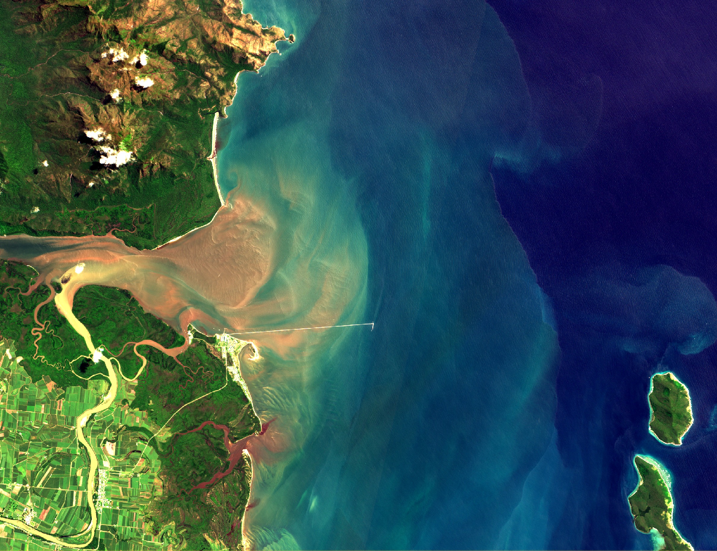
Lucinda Jetty Coastal Observatory is a ground-based facility, located at the end of the Lucinda Jetty, nearly 6 km off the Queensland coast near the mouth of the Herbert River. This places it at the border of the wet and dry tropical regions off the northeast coast of Australia. Capturing both atmospheric and marine data, the observatory is used to validate optical satellite observations and to help advance our understanding of the link between these observations to support the study of bio-geochemical processes and modelling. Established and managed in collaboration with the Integrated Marine Observing System (IMOS), it is currently the only fixed-platform in Australia making sustained observations of this nature.
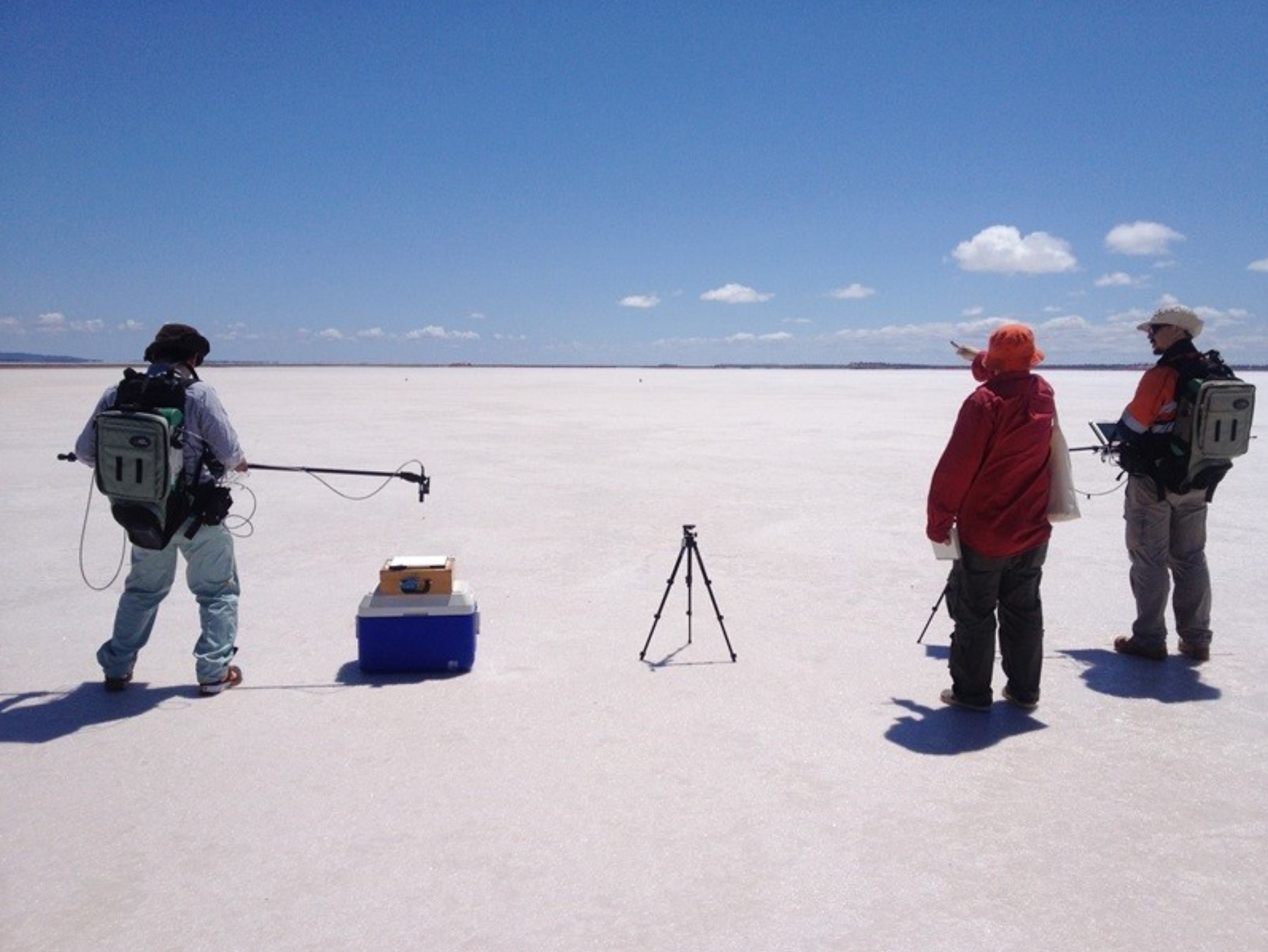
We have developed an autonomous vicarious calibration site at the Pinnacles Desert approximately 200km from Perth in Western Australia. Designed to support future spaceborne imaging spectroscopy sensors, it is also contributing to the calibration of other multispectral optical sensors such as Landsat 8 and Sentinel-2. Instruments on the site have been acquiring continuous radiometric data and associated meteorological and atmospheric composition data since May 2022. The site is currently supporting calibration and validation efforts of the EnMAP and DESIS missions, with collaborative activities for the PRISMA, EMIT, and future ESA CHIME missions.
We are also developing a dark-water inland observatory at Googong Dam in NSW, south of Canberra. The observatory will provide water quality validation data for satellite-derived water quality products. The site is expected to be operational in 2024.
Discover more about Earth observation and calibration and validation in Australia
- Australian Space Agency’s Earth Observation from Space Roadmap
- AusCalVal report [pdf · 7mb]
- TERN Landscape Monitoring and Observation
- IMOS Satellite Remote Sensing
- AquaWatch Australia mission
Data from Earth observation satellites increasingly underpins reporting, assessment and decision-making by governments on important global issues such as sustainable development goals, climate change, and land degradation. End-users require confidence in the data they rely on, ensuring it is reliable, traceable, and repeatable.
It is also vital that data from different satellites, or data collected between dates by the same satellite sensor, can be seamlessly used and accurately compared to make quantitative use of Earth observation data, maintain the scientific value of data archives, and meet stringent regulatory or legal constraints.
Satellite calibration and validation is similar to quality control on a production line. Calibrating sensors ensures the data they capture is aligned with physical standards. The process of validation checks that products derived from the satellite data are comparable to ground measurements, and verifies that the space-derived measurements are a true representation of what is happening on the ground.
Sensors and ground stations
Over four decades we have developed unique expertise in the application of Earth observation data as well as the development of sensors, infrastructure, and practices to calibrate sensors and validate data products.
We operate satellite sensor calibration and validation infrastructure across Australia and conduct dedicated field campaigns to help calibrate several Earth observation satellites. Our capability is highly valued by our international partners.
Lucinda Jetty Coastal Observatory is a ground-based facility, located at the end of the Lucinda Jetty, nearly 6 km off the Queensland coast near the mouth of the Herbert River. This places it at the border of the wet and dry tropical regions off the northeast coast of Australia. Capturing both atmospheric and marine data, the observatory is used to validate optical satellite observations and to help advance our understanding of the link between these observations to support the study of bio-geochemical processes and modelling. Established and managed in collaboration with the Integrated Marine Observing System (IMOS), it is currently the only fixed-platform in Australia making sustained observations of this nature.
We have developed an autonomous vicarious calibration site at the Pinnacles Desert approximately 200km from Perth in Western Australia. Designed to support future spaceborne imaging spectroscopy sensors, it is also contributing to the calibration of other multispectral optical sensors such as Landsat 8 and Sentinel-2. Instruments on the site have been acquiring continuous radiometric data and associated meteorological and atmospheric composition data since May 2022. The site is currently supporting calibration and validation efforts of the EnMAP and DESIS missions, with collaborative activities for the PRISMA, EMIT, and future ESA CHIME missions.
We are also developing a dark-water inland observatory at Googong Dam in NSW, south of Canberra. The observatory will provide water quality validation data for satellite-derived water quality products. The site is expected to be operational in 2024.
Discover more about Earth observation and calibration and validation in Australia
- Australian Space Agency’s Earth Observation from Space Roadmap
- AusCalVal report [pdf · 7mb]
- TERN Landscape Monitoring and Observation
- IMOS Satellite Remote Sensing
- AquaWatch Australia mission