About the assessment
New knowledge of the iconic Great Artesian Basin (GAB) is now available, with the release of the first comprehensive study of the resource since 1980.
The Australian Government Department of Sustainability, Environment, Water, Population and Communities and the National Water Commission engaged CSIRO and Geoscience Australia to undertake the Great Artesian Basin Water Resource Assessment, which was delivered in March 2013.
The A$6.25 million Assessment involved a basin-scale investigation of water resources and the potential impacts of climate change and groundwater development to 2070, and was completed over two-and-a-half years. It provided an analytical framework to assist water managers in the GAB.
Importantly, the Assessment brought together knowledge of the geology and hydrology in a consistent way for the whole GAB.
Knowledge of the GAB is ongoing and this new research provides a better understanding of the GAB that will enable future management to take into account the complexity of the system where appropriate.
Findings
The Assessment revealed that the complex geological features such as faults and ridges govern groundwater movement in the GAB. It identified areas where underlying geological basins and overlying shallow groundwater are potentially connected with aquifers of the GAB.
The Assessment also demonstrates that groundwater has a greater potential to move vertically across GAB formations than previously thought.
This Assessment contributed to building a national picture of our water resources and is a continuation of the Sustainable Yields projects that have been undertaken by CSIRO and partners since 2007.
Assessment location
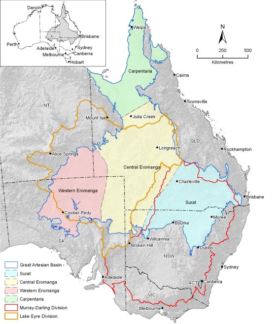
The GAB covers more than 1.7 million square kilometres and underlies parts of Queensland, New South Wales, South Australia and the Northern Territory (see the map below).

