The $11.4 million Northern Rivers Resilience Initiative aims to help the Australian Government understand the drivers behind the unprecedented flood events in February-March 2022 in this region of NSW and develop community-supported solutions for flood mitigation and resilience investment.
The National Emergency Management Agency (NEMA) has engaged Australia’s national science agency CSIRO to support the Initiative, which will consider climate, catchment and hydrological systems, and the broader influences of land-use practice and infrastructure.
 The project consists of two phases:
1. Rapid review and assessment phase (completed) – the first six months (July to November 2022). This phase identified and prioritised existing project proposals. It analysed the most effective intervention options for allocation of the Federal Government’s $150 million funding and characterised the catchment and climate conditions which led to the 2022 floods. Residents and councils, in each of the seven flood-affected Local Government Areas in the region (Ballina, Byron, Clarence Valley, Kyogle, Lismore, Richmond Valley and Tweed) were consulted to help identify and prioritise the most effective intervention options.
Outcome – CSIRO completed the rapid review and assessment phase and submitted two related reports to NEMA on 30 November 2022. These reports and a full list of project recommendations were then considered by the Federal and NSW governments.
On 23 February 2023, the first 16 projects totalling $50 million were announced. These included combined upgrades to pumps and pump stations in Lismore, a new pump system to assist drainage in East Murwillumbah and installation of box culverts through a riverbank levee to improve local drainage in Grafton.
On 28 July 2023, the second 20 projects totalling $100 million were announced. These included raising two low bridges at Tatham to improve access between Casino and Coraki during flood events and widening the Browns Creek flood channel at Lismore.
CSIRO and NEMA have completed phase one of the Northern Rivers Resilience Initiative project with the allocation of the total $150 million Federal Government funds for flood mitigation and resilience projects in the Northern Rivers region.
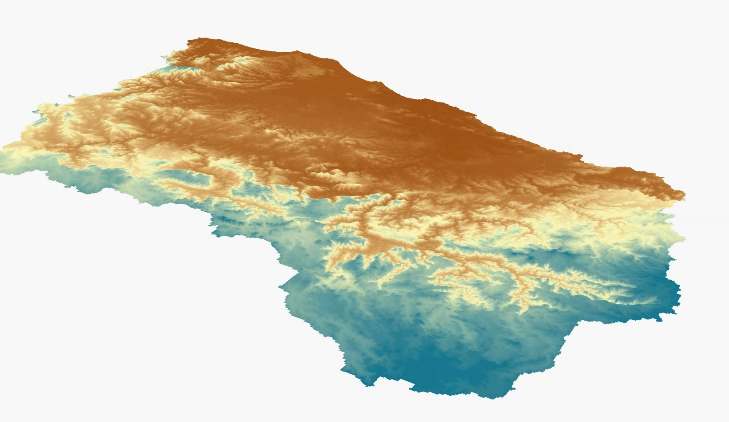
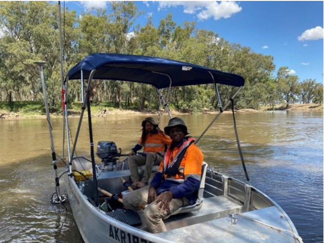
2. Detailed modelling – longer term (ongoing). This work generated Light Detection and Ranging (LiDAR) data (using planes) to inform spatial analysis for the entire Northern Rivers region. River bathymetry (using boats) was also collected for the Richmond and Tweed rivers and parts of the Brunswick. All this high-quality data will be used to underpin a detailed hydrodynamic model for the Richmond River catchment.
Outcome – The quality assessed LiDAR and Bathymetry datasets became publicly available on 28 June 2024 through the Geoscience Australia Elvis website. This was the first time high-quality LiDAR and river floor mapping data (for three rivers) had been captured and made available for the Northern Rivers region. Such a comprehensive overview of the river systems in the NSW Northern Rivers region will provide an evidence base for future planning, including reducing the impacts of floods.
Some highlights of the data include:
- LiDAR data was used to build a three-dimensional digital surface map of the Northern Rivers region in New South Wales (NSW), covering more than 30,000 km².
- River floor mapping data was used to develop a three-dimensional surface and visualisation of the Richmond, Tweed, and parts of the Brunswick rivers in the Northern Rivers region.
- The LiDAR and river bathymetry data forms the critical scientific evidence base that can be used by the NSW Government, local councils, and non-government organisations such as Universities for a range of other purposes including the following:
- Land use, housing, transport, and infrastructure planning,
- Environmental, ecological and hydrological studies, and;
- Flood mitigation strategies and plans for the Northern Rivers region.
The LiDAR and river bathymetry data are essential inputs for the detailed hydrodynamic model for the Richmond River catchment, to be developed by CSIRO through NRRI Phase Two. The model is currently being built and will accurately represent water flow, depth, and velocity across the Richmond River catchment (more than 7000 km²). The model will be completed on 30 June 2025 and a technical report will be available outlining the calibration and validation for the Richmond River catchment. The model will also be available to those who have the appropriate software license. The hydrodynamic model will then be used by CSIRO to test and investigate flood mitigation options for the Northern Rivers region well into 2026. Testing these flood mitigation options will help inform planning resilience and readiness activities to reduce the effects of future flooding in the region. The testing of mitigation options will be done in conjunction with State, Federal and Local Government input.
Community and stakeholder engagement
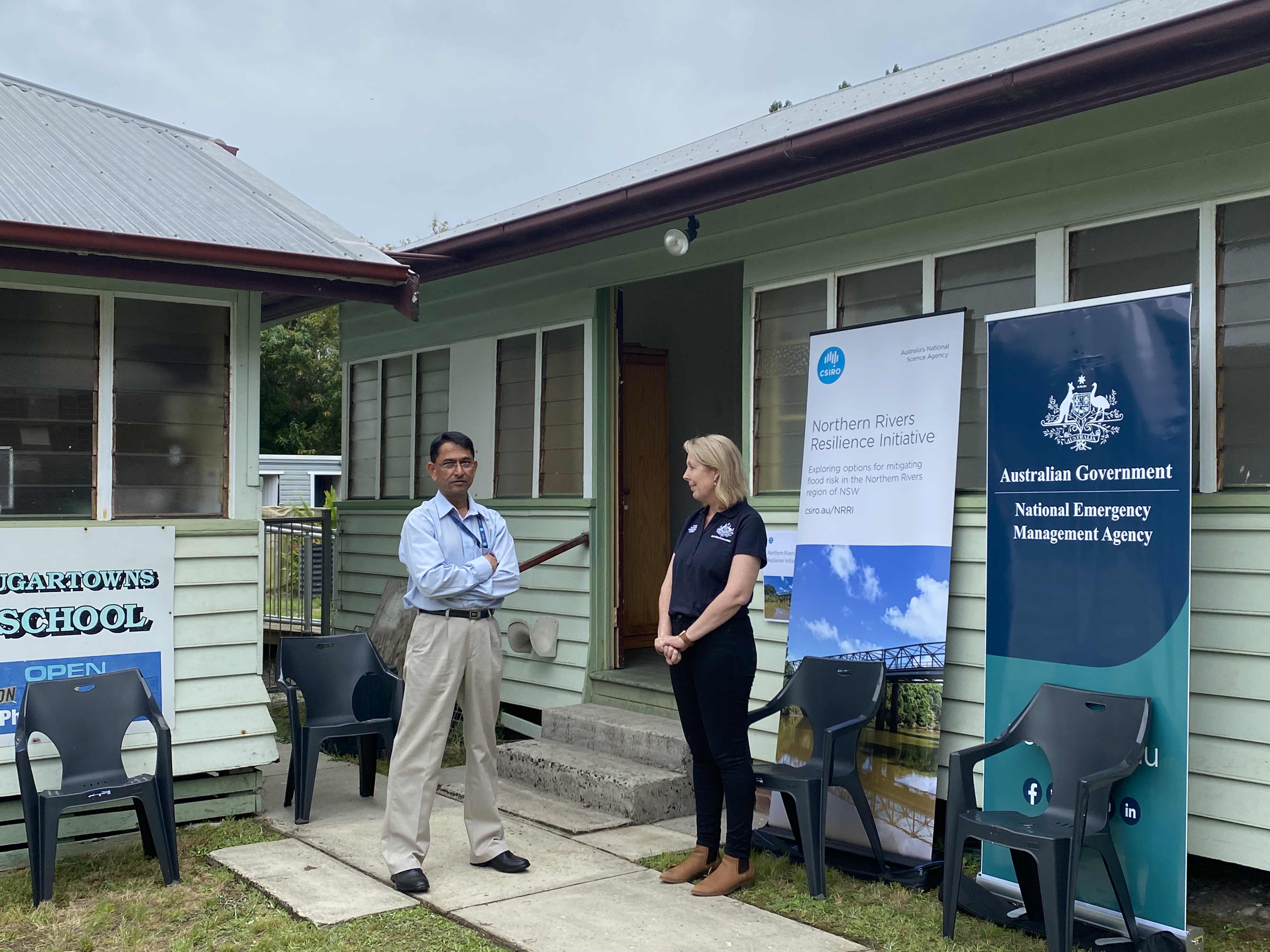
A core part of the first phase of the project was to engage with residents in flood-affected areas to seek their views regarding priorities for investment. CSIRO and NEMA provide regular updates on NRRI progress on our websites as well as regular updates to project governance and advisory panels, the Northern Rivers Joint Organisation (NRJO), local councils, stakeholders and communities. For further details please email nrri@csiro.au or contact@nema.gov.au
Frequently asked questions
From your analysis so far, what led to the extreme 2022 flood event in the Northern Rivers region?
Between the 23 February and 1 March, the highest daily rainfall totals were felt in most parts of the Richmond, Tweed and Brunswick areas. Conditions were already significantly wetter than average across the Northern Rivers region with rainfall totals, soil moisture and groundwater levels remaining above their 75th percentile during the two months preceding the flood. Extreme rainfalls translated into record high stream flows, volumes and water levels. Major flood levels were exceeded by more than 2 metres in several locations including in Lismore where the flood reached a record 14.37 metres.
Can you explain the two different methods researchers used to collect data?
LiDAR flights – An aeroplane with LiDAR sensors attached flew over the region. These sensors were a remote sensing method used to collect accurate digital elevation models for the region for hydrodynamic modelling. There were also ground crews conducting surveys to truth-test information collected by the LiDAR equipment attached to the plane.
River bathymetry – Boats in the rivers with sonar equipment collected accurate information on the cross sections of the river network (river bathymetry) to inform the hydrodynamic model. This included small remote-controlled boats for smaller and steeper streams.
Has Phase 2 of the NRRI been delayed and if so, why?
 LiDAR and bathymetry data collection commenced in July 2022. There were significant delays to the LiDAR collection due to unfavourable weather conditions across the region over the last year. This mostly affected the ability to fly planes for LiDAR collection.
Can you describe the LiDAR and bathymetry datasets in more detail?
The LiDAR data is the first consistent high-quality topography dataset across the whole Northern River’s region covering more than 30,000 km² collected after the 2022 floods. It is quality assessed and is highly accurate with point density averages around 16 points per square metre and suitable for any detailed modelling.
This bathymetry data is the first consistent high-quality dataset for the main tributaries of the Richmond and Tweed rivers and sections of the Brunswick River in Northern Rivers region (~500 km). It was collected using side scan sonar which collects continuous river cross sections (every 1 m) which is very high quality and suitable for any detailed modelling. The bathymetry for major water storages in the region is also available providing accurate water storage capacity.
How can the public access and download the LiDAR and bathymetry data?
All the LiDAR and bathymetry data has been made available on the Geoscience Australia website. The ELVIS webpage provides step by step guidance to access and download the data for the area of interest. Almost all topography and bathymetry/seabed data collected by Australian agencies is made available to users through this website.
How can the LiDAR and bathymetry data be used by councils?
The data forms the critical scientific evidence base that can be used by the NSW Government, local councils, and non-government organisations for a range of other purposes including:
- land use
- transport and housing planning
- environmental and ecological studies
- hydrological assessments, and
- flood mitigation strategies and plans for the Northern Rivers region.
Will governments and other agencies need CSIRO expertise to interpret the data correctly?
Detailed metadata will be made available with the dataset explaining exactly what the datasets are along with detailed technical specifications. If there are any more specific questions, NEMA and CSIRO will be able to assist further.
What is the model that CSIRO is building for the Richmond River catchment?
The model is a hydrodynamic model (HD), which is a representation of water flows across the Richmond River catchment (more than 7000 km²). The model aims to represent the key hydrological (water flow) processes related to flooding across the catchment and will be able to reproduce the past flooding history in the catchment. Once completed, the model can be used to investigate the changes in flooding associated with changed climate, and structural and non-structural infrastructure options designed to mitigate flooding. The model design is based on detailed spatial representation of the catchment’s biophysical characteristics such as soils (infiltration rates, soil storage capacity, etc) and landscapes (roughness, flow paths, flow direction, structures, vegetation, etc.).
The hydrodynamic model will be validated (checked for accuracy) against:
- flood extents mapped through remote sensing (using satellite products from Landsat, Sentinel, etc.),
- measurements at internal flow gauges and
- on-ground observations.
This will provide confidence in the model to be used for any future climate change or flood mitigation scenario analysis.
Why are you only developing a detailed hydrodynamic model for the Richmond River Catchment?
The focus on Richmond arises from the continual incidence of flooding and likely compounding impacts that come from a changed climate and hydrology. Lessons from the NRRI project will be applicable across the region. The LiDAR and river bathymetry data form the critical scientific evidence base that can be used by the NSW Government and local councils to inform future flood mitigation strategies and plans for all local government areas in the Northern Rivers region.
What are the long-term goals of the project?
We will continue to conduct our detailed modelling work until 2025 when we will start investigating different flood mitigation scenarios to recommend long term flood mitigation actions. Multiple flood mitigation/adaptation scenarios and the level of protection they can provide along with the associated costs can be investigated once we have a full catchment model calibrated for the Richmond River catchment. We will develop recommendations to inform planning resilience and readiness activities to reduce the effects of future flooding disasters in the Northern Rivers region. We will also continue to communicate and work closely with the councils and the community.
The $11.4 million Northern Rivers Resilience Initiative aims to help the Australian Government understand the drivers behind the unprecedented flood events in February-March 2022 in this region of NSW and develop community-supported solutions for flood mitigation and resilience investment.
The National Emergency Management Agency (NEMA) has engaged Australia’s national science agency CSIRO to support the Initiative, which will consider climate, catchment and hydrological systems, and the broader influences of land-use practice and infrastructure.
The project consists of two phases:
1. Rapid review and assessment phase (completed) – the first six months (July to November 2022). This phase identified and prioritised existing project proposals. It analysed the most effective intervention options for allocation of the Federal Government’s $150 million funding and characterised the catchment and climate conditions which led to the 2022 floods. Residents and councils, in each of the seven flood-affected Local Government Areas in the region (Ballina, Byron, Clarence Valley, Kyogle, Lismore, Richmond Valley and Tweed) were consulted to help identify and prioritise the most effective intervention options.
Outcome – CSIRO completed the rapid review and assessment phase and submitted two related reports to NEMA on 30 November 2022. These reports and a full list of project recommendations were then considered by the Federal and NSW governments.
On 23 February 2023, the first 16 projects totalling $50 million were announced. These included combined upgrades to pumps and pump stations in Lismore, a new pump system to assist drainage in East Murwillumbah and installation of box culverts through a riverbank levee to improve local drainage in Grafton.
On 28 July 2023, the second 20 projects totalling $100 million were announced. These included raising two low bridges at Tatham to improve access between Casino and Coraki during flood events and widening the Browns Creek flood channel at Lismore.
CSIRO and NEMA have completed phase one of the Northern Rivers Resilience Initiative project with the allocation of the total $150 million Federal Government funds for flood mitigation and resilience projects in the Northern Rivers region.
2. Detailed modelling – longer term (ongoing). This work generated Light Detection and Ranging (LiDAR) data (using planes) to inform spatial analysis for the entire Northern Rivers region. River bathymetry (using boats) was also collected for the Richmond and Tweed rivers and parts of the Brunswick. All this high-quality data will be used to underpin a detailed hydrodynamic model for the Richmond River catchment.
Outcome – The quality assessed LiDAR and Bathymetry datasets became publicly available on 28 June 2024 through the Geoscience Australia Elvis website. This was the first time high-quality LiDAR and river floor mapping data (for three rivers) had been captured and made available for the Northern Rivers region. Such a comprehensive overview of the river systems in the NSW Northern Rivers region will provide an evidence base for future planning, including reducing the impacts of floods.
Some highlights of the data include:
- LiDAR data was used to build a three-dimensional digital surface map of the Northern Rivers region in New South Wales (NSW), covering more than 30,000 km².
- River floor mapping data was used to develop a three-dimensional surface and visualisation of the Richmond, Tweed, and parts of the Brunswick rivers in the Northern Rivers region.
- The LiDAR and river bathymetry data forms the critical scientific evidence base that can be used by the NSW Government, local councils, and non-government organisations such as Universities for a range of other purposes including the following:
- Land use, housing, transport, and infrastructure planning,
- Environmental, ecological and hydrological studies, and;
- Flood mitigation strategies and plans for the Northern Rivers region.
The LiDAR and river bathymetry data are essential inputs for the detailed hydrodynamic model for the Richmond River catchment, to be developed by CSIRO through NRRI Phase Two. The model is currently being built and will accurately represent water flow, depth, and velocity across the Richmond River catchment (more than 7000 km²). The model will be completed on 30 June 2025 and a technical report will be available outlining the calibration and validation for the Richmond River catchment. The model will also be available to those who have the appropriate software license. The hydrodynamic model will then be used by CSIRO to test and investigate flood mitigation options for the Northern Rivers region well into 2026. Testing these flood mitigation options will help inform planning resilience and readiness activities to reduce the effects of future flooding in the region. The testing of mitigation options will be done in conjunction with State, Federal and Local Government input.
Community and stakeholder engagement
A core part of the first phase of the project was to engage with residents in flood-affected areas to seek their views regarding priorities for investment. CSIRO and NEMA provide regular updates on NRRI progress on our websites as well as regular updates to project governance and advisory panels, the Northern Rivers Joint Organisation (NRJO), local councils, stakeholders and communities. For further details please email nrri@csiro.au or contact@nema.gov.au
Frequently asked questions
From your analysis so far, what led to the extreme 2022 flood event in the Northern Rivers region?
Between the 23 February and 1 March, the highest daily rainfall totals were felt in most parts of the Richmond, Tweed and Brunswick areas. Conditions were already significantly wetter than average across the Northern Rivers region with rainfall totals, soil moisture and groundwater levels remaining above their 75th percentile during the two months preceding the flood. Extreme rainfalls translated into record high stream flows, volumes and water levels. Major flood levels were exceeded by more than 2 metres in several locations including in Lismore where the flood reached a record 14.37 metres.
Can you explain the two different methods researchers used to collect data?
LiDAR flights – An aeroplane with LiDAR sensors attached flew over the region. These sensors were a remote sensing method used to collect accurate digital elevation models for the region for hydrodynamic modelling. There were also ground crews conducting surveys to truth-test information collected by the LiDAR equipment attached to the plane.
River bathymetry – Boats in the rivers with sonar equipment collected accurate information on the cross sections of the river network (river bathymetry) to inform the hydrodynamic model. This included small remote-controlled boats for smaller and steeper streams.
Has Phase 2 of the NRRI been delayed and if so, why?
LiDAR and bathymetry data collection commenced in July 2022. There were significant delays to the LiDAR collection due to unfavourable weather conditions across the region over the last year. This mostly affected the ability to fly planes for LiDAR collection.
Can you describe the LiDAR and bathymetry datasets in more detail?
The LiDAR data is the first consistent high-quality topography dataset across the whole Northern River’s region covering more than 30,000 km² collected after the 2022 floods. It is quality assessed and is highly accurate with point density averages around 16 points per square metre and suitable for any detailed modelling.
This bathymetry data is the first consistent high-quality dataset for the main tributaries of the Richmond and Tweed rivers and sections of the Brunswick River in Northern Rivers region (~500 km). It was collected using side scan sonar which collects continuous river cross sections (every 1 m) which is very high quality and suitable for any detailed modelling. The bathymetry for major water storages in the region is also available providing accurate water storage capacity.
How can the public access and download the LiDAR and bathymetry data?
All the LiDAR and bathymetry data has been made available on the Geoscience Australia website. The ELVIS webpage provides step by step guidance to access and download the data for the area of interest. Almost all topography and bathymetry/seabed data collected by Australian agencies is made available to users through this website.
How can the LiDAR and bathymetry data be used by councils?
The data forms the critical scientific evidence base that can be used by the NSW Government, local councils, and non-government organisations for a range of other purposes including:
- land use
- transport and housing planning
- environmental and ecological studies
- hydrological assessments, and
- flood mitigation strategies and plans for the Northern Rivers region.
Will governments and other agencies need CSIRO expertise to interpret the data correctly?
Detailed metadata will be made available with the dataset explaining exactly what the datasets are along with detailed technical specifications. If there are any more specific questions, NEMA and CSIRO will be able to assist further.
What is the model that CSIRO is building for the Richmond River catchment?
The model is a hydrodynamic model (HD), which is a representation of water flows across the Richmond River catchment (more than 7000 km²). The model aims to represent the key hydrological (water flow) processes related to flooding across the catchment and will be able to reproduce the past flooding history in the catchment. Once completed, the model can be used to investigate the changes in flooding associated with changed climate, and structural and non-structural infrastructure options designed to mitigate flooding. The model design is based on detailed spatial representation of the catchment’s biophysical characteristics such as soils (infiltration rates, soil storage capacity, etc) and landscapes (roughness, flow paths, flow direction, structures, vegetation, etc.).
The hydrodynamic model will be validated (checked for accuracy) against:
- flood extents mapped through remote sensing (using satellite products from Landsat, Sentinel, etc.),
- measurements at internal flow gauges and
- on-ground observations.
This will provide confidence in the model to be used for any future climate change or flood mitigation scenario analysis.
Why are you only developing a detailed hydrodynamic model for the Richmond River Catchment?
The focus on Richmond arises from the continual incidence of flooding and likely compounding impacts that come from a changed climate and hydrology. Lessons from the NRRI project will be applicable across the region. The LiDAR and river bathymetry data form the critical scientific evidence base that can be used by the NSW Government and local councils to inform future flood mitigation strategies and plans for all local government areas in the Northern Rivers region.
What are the long-term goals of the project?
We will continue to conduct our detailed modelling work until 2025 when we will start investigating different flood mitigation scenarios to recommend long term flood mitigation actions. Multiple flood mitigation/adaptation scenarios and the level of protection they can provide along with the associated costs can be investigated once we have a full catchment model calibrated for the Richmond River catchment. We will develop recommendations to inform planning resilience and readiness activities to reduce the effects of future flooding disasters in the Northern Rivers region. We will also continue to communicate and work closely with the councils and the community.