The challenge
Geochemical landscape evolution of regions under cover
Australia is an ancient continent. Approximately 85 per cent of South Western Australia is covered by an overburden of weathered rock and sediments, called regolith, which can be as thick as 150 metres in places.
Surface geochemistry is often used as a primary vector in mineral exploration to locate the footprints of ore deposits beneath the surface.
The presence of this thick cover, composed of variable geology, creates a significant challenges for mineral exploration, since the geochemical analysis of surface samples may display a poor understanding of the geology at depth.
Our response
Modelling the geochemistry of naturally altered landscapes
By integrating multiple geomorphological, geological, geochemical and geophysical data sets, we are building an integrated picture of the architecture of the cover and how the geochemical elements have moved through time within it.
This knowledge is helping explorers to improve predictive geochemical models to help pinpoint potential exploration targets deep below the surface in the south east of Australia.

The results
A new landscape evolution model of the south east Western Australia
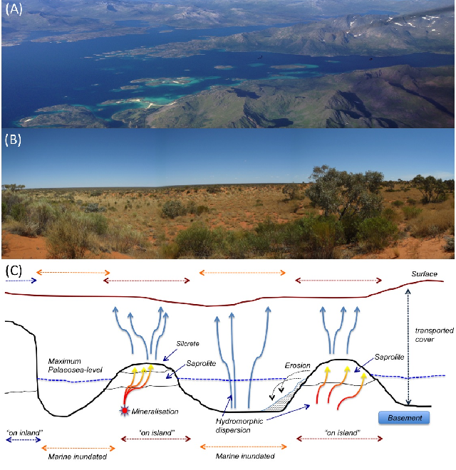
We developed a new model of south east Western Australia, showing how the landscape has evolved over time.
This model describes extensive and diverse type of erosion and sedimentation of the cover throughout the region. It shows how some of the dominant landforms have been produced by successive marine transgression and regression cycles, with numerous islands and estuarine zones buried under the cover today.
Mapping the ancient coastlines, identifying buried islands and estuarine zones, and uncovering the extent of marine sediment inland, is now helping mineral explorers plan and execute campaigns to diocover new ore deposits in the region.
