The challenge
Slow and expensive measurement of soil properties is preventing Australian farmers from fully embracing emerging digital technologies
Direct measurement of soil properties and crop roots is slow and expensive. There is a need for better soil information in order for Australia to capture the full potential of emerging digital agriculture technologies, and therefore to stay competitive.
While the Soil and Landscape Grid of Australia (SLGA) provides interpolated soil properties across space, the accuracy of many key soil properties is low due to interpolation of limited measured data at sites sparsely distributed across the country. Key functional soil properties like PAWC are not accurate enough at scales needed for farm management decisions. More accurate data are needed to support improved modelling of crops, inform management decisions and enable accurate forecasting of yields.
Our response
An affordable and efficient approach to predicting functional soil properties
New field and remotely sensed data streams, combined with process-based soil-plant systems modelling, provide an opportunity for an alternative and more efficient approach to predicting functional soil properties.

Through CSIRO’s Digiscape Future Science Platform, we have been able to develop novel methods to generate new predictions of plant available water capacity (PAWC) of soils and related soil hydraulic properties, beyond the current soil grid.
These include an inverse modelling approach at paddock and sub-paddock scales and a spatial modelling approach applied right across the cropping regions of Australia.
The results will complement and be used to improve Australia's digital soil map, which is a critical component in next-generation assisted decision making in agriculture and environmental management.
The results
Predicting plant available water capacity (PAWC) of soils from carefully monitoring crops and recording management inputs
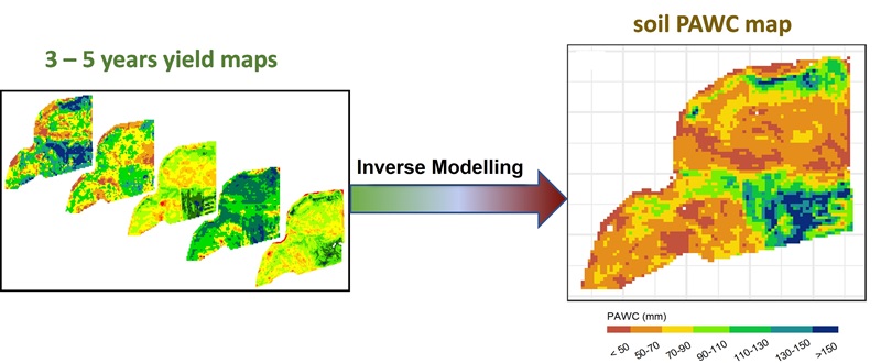
An inverse modelling approach has been developed to predict plant available water holding capacity (PAWC) from easily measurable plant properties, such as yield, biomass and potentially remotely sensed vegetation indices, together with onsite management information and readily available climate data.
This approach successfully predicted PAWC from crop yield at sub-paddock scale with an error less than 25 mm. It also predicted soil PAWC at finer scale using high resolution yield maps (see image above).
A spatial modelling approach has also been developed with machine learning to identify key bioclimatic variables, topographical indices and remotely sensed vegetation indices to predict spatial variations of soil hydraulic properties across Australia's agricultural region. Saturation water content (SAT), drained upper limit (DUL), water content at 15 bar suction (LL15), and available water capacity (AWC) of soil were predicted down to 2m depth at 90m spatial resolution across the agricultural regions of Australia.
