RV Investigator's weather radar records the first data from oceans around Australia. This data is used to improve climate models and weather predictions for Australia.
Share
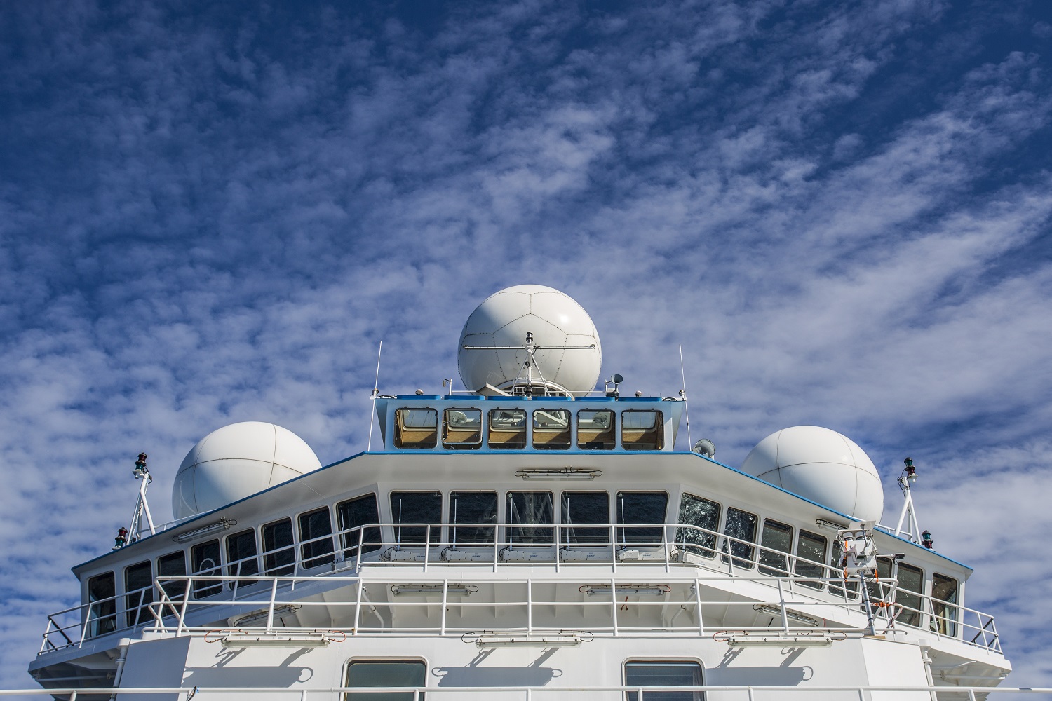
Where it's located
The weather radar is the impressive large soccer ball shaped object located on the top of the ship.
What the weather radar is used for
The weather radar sends and receives microwave pulses to collect atmospheric data. This data is used to improve climate models and weather predictions for Australia.
How it works
It's capable of gathering data anywhere in a 150 kilometre radius around the ship: from clouds towering 20 kilometres over the tropical ocean—to cold ice storms in the Antarctic.
The pulse has a vertical and horizontal signal, called dual polarisation. The returning signal reveals the quantity, location, size and shape of any precipitation - water, snow or ice.
VIDEO: Weather radar on RV Investigator
Your video or audio is here! ID: {CB0C9768-2371-4883-ADA0-AC0E934BFF58}
The weather radar is the impressive large soccer ball shaped object located on the top of the ship.
What the weather radar is used for
The weather radar sends and receives microwave pulses to collect atmospheric data. This data is used to improve climate models and weather predictions for Australia.
How it works
It's capable of gathering data anywhere in a 150 kilometre radius around the ship: from clouds towering 20 kilometres over the tropical ocean—to cold ice storms in the Antarctic.
The pulse has a vertical and horizontal signal, called dual polarisation. The returning signal reveals the quantity, location, size and shape of any precipitation - water, snow or ice.
VIDEO: Weather radar on RV Investigator
[Music plays and plankton appear on screen with text: Marine National Facility]
[Camera pans over a school of southern bluefin tuna]
[Image changes to show an animation of RV Investigator]
[Text appears: RV Investigator Weather Radar]
[Camera zooms in on the weather radar and text appears: The weather radar on top of Investigator sends and receives microwave pulses.]
[Camera zooms in on the radar emitting microwave pulses]
[Text appears: The radar sends 800 pulses every second.]
[Camera zooms out on Investigator and shows the area where the radar can collect data. Text appears: Data is collected within a 150 km radius from the ship and 20 km into the atmosphere.]
[Camera pans skyward to show precipitation. Text appears: The pulse has a vertical and horizontal signal, called dual polarisation. The returning signal reveals the quantity, location, size and shape of any precipitation.]
[Image changes to show pictures of water, snow and ice. Text appears: Scientists will be able to see if a cloud is made from water, snow or ice]
[Image changes to show an aerial shot of landmasses surrounded by ocean. Text appears: Land-based radars already collect data for scientists. The radar on Investigator will record the first data from the oceans around Australia. Footnote appears: Stuart Ramsden, National Computational Infrastructure, & Todd Lane, the Centre of Excellence for Climate System Science, University of Melbourne.]
[Image changes to show weather systems moving over the landmasses and surrounding oceans. Text appears: The data will be used to improve climate models and weather predictions for Australia.]
[CSIRO logo appears with text: Big ideas start here www.csiro.au]
We have received your enquiry and will reply soon.
We're Sorry
The contact form is currently unavailable. Please try again later. If this problem persists, please call us with your enquiry on 1300 363 400 or +61 3 9545 2176. We are available from 9.00 am to 4.00 pm AEST Monday - Friday.
 Where it's located